ملف:Sixteenth Street Historic District map.png
لا توجد دقة أعلى متوفرة.
Sixteenth_Street_Historic_District_map.png (406 × 586 بكسل حجم الملف: 265 كيلوبايت، نوع MIME: image/png)
| ⧼wm-license-information-description⧽ |
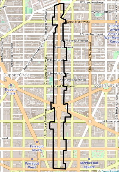
English: Map showing the boundaries of the Sixteenth Street Historic District in Washington, D.C. The historic district is listed on the National Register of Historic Places. Boundaries are derived from the map provided by the District of Columbia's Office of Planning.
|
||
| ⧼wm-license-information-date⧽ | 2020 | ||
| ⧼wm-license-information-source⧽ | Screenshot of OpenStreetMap's map of the 16th Street NW vicinity, with district boundary lines drawn by uploader | ||
| ⧼wm-license-information-author⧽ | OpenStreetMap editors (map), AgnosticPreachersKid (district boundaries) | ||
| ⧼wm-license-information-permission⧽ (⧼wm-license-information-permission-reusing-text⧽) |
My work is public domain, and the original map is |
تاريخ الملف
اضغط على زمن/تاريخ لرؤية الملف كما بدا في هذا الزمن.
| زمن/تاريخ | صورة مصغرة | الأبعاد | مستخدم | تعليق | |
|---|---|---|---|---|---|
| حالي | ★ مراجعة معتمدة 20:34، 11 نوفمبر 2023 | | 406 × 586 (265 كيلوبايت) | Pastakhov (نقاش | مساهمات) | Upload https://upload.wikimedia.org/wikipedia/commons/c/c8/Sixteenth_Street_Historic_District_map.png |
لا يمكنك استبدال هذا الملف.
وصلات
لا يوجد صفحات تصل لهذه الصورة.