ملف:Scotland Administrative Map 1947.png

حجم هذه المعاينة: 345 × 600 بكسل. البعد الآخر: 2٬001 × 3٬480 بكسل.
الملف الأصلي (2٬001 × 3٬480 بكسل حجم الملف: 2٫32 ميجابايت، نوع MIME: image/png)
وصف قصير
| ⧼wm-license-information-description⧽ |
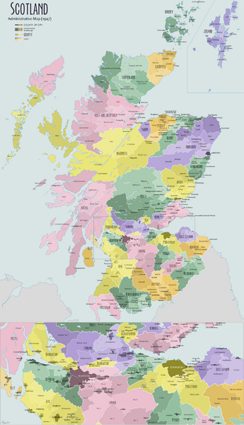
English: Administrative map of Scotland in 1947. Showing counties and districts, counties of cities, large and small Burghs
|
| ⧼wm-license-information-date⧽ | 2009 |
| ⧼wm-license-information-source⧽ | ⧼Wm-license-own-work⧽ |
| ⧼wm-license-information-author⧽ | XrysD |
| ⧼wm-license-information-other-versions⧽ |
ترخيص
|

تاريخ الملف
اضغط على زمن/تاريخ لرؤية الملف كما بدا في هذا الزمن.
| زمن/تاريخ | صورة مصغرة | الأبعاد | مستخدم | تعليق | |
|---|---|---|---|---|---|
| حالي | ★ مراجعة معتمدة 02:47، 5 نوفمبر 2023 | | 2٬001 × 3٬480 (2٫32 ميجابايت) | Pastakhov (نقاش | مساهمات) | Upload https://upload.wikimedia.org/wikipedia/commons/b/b5/Scotland_Administrative_Map_1947.png |
لا يمكنك استبدال هذا الملف.
وصلات
لا يوجد صفحات تصل لهذه الصورة.