ملف:Santorini Oia (cropped).jpg
حجم هذه المعاينة: 800 × 114 بكسل. البعد الآخر: 1٬459 × 208 بكسل.
الملف الأصلي (1٬459 × 208 بكسل حجم الملف: 106 كيلوبايت، نوع MIME: image/jpeg)
وصف قصير
| ⧼wm-license-information-description⧽ |
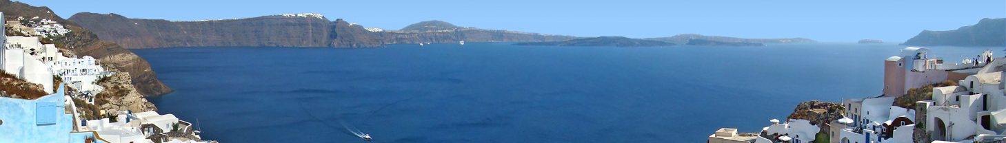
English: Oia, Santorini, Greece. The circle of land collapsed following the ancient volcanic eruption is evident here. From left to beyond the centre at the horizon lies the southern part of the Santorini island, with the caldera plunging into the sea. On the right are the neighbouring islets of Nea Kameni, Palaia Kameni, Aspronisi and Thirasia, all part of the bigger island before the collapse.
Français : Oia, Santorin, Grèce. Le cercle de terre qui s'était affaissé après l'éruption volcanique de l'antiquité est évident ici. De gauche à passé le centre à l'horizon s'étend la partie sud de l'île de Santorin, avec la caldera plongeant dans la mer. Vers la droite sont visibles les îlots de Nea Kameni, Palaia Kameni, Aspronisi et Thirasia, toutes faisant partie de la plus grande île qui existait avant l'affaissement.
|
| ⧼wm-license-information-date⧽ | 2011 |
| ⧼wm-license-information-source⧽ | ⧼Wm-license-own-work⧽ |
| ⧼wm-license-information-author⧽ | Tango7174 |
قالب:Location dec قالب:Extracted from
ترخيص
|


تاريخ الملف
اضغط على زمن/تاريخ لرؤية الملف كما بدا في هذا الزمن.
| زمن/تاريخ | صورة مصغرة | الأبعاد | مستخدم | تعليق | |
|---|---|---|---|---|---|
| حالي | ★ مراجعة معتمدة 01:44، 9 نوفمبر 2023 | 1٬459 × 208 (106 كيلوبايت) | Pastakhov (نقاش | مساهمات) | Upload https://upload.wikimedia.org/wikipedia/commons/9/9e/Santorini_Oia_%28cropped%29.jpg |
لا يمكنك استبدال هذا الملف.
وصلات
لا يوجد صفحات تصل لهذه الصورة.
.jpg&oldid=3418588)