ملف:Samoa Savaii map.png
لا توجد دقة أعلى متوفرة.
Samoa_Savaii_map.png (416 × 256 بكسل حجم الملف: 54 كيلوبايت، نوع MIME: image/png)
وصف قصير
| ⧼wm-license-information-description⧽ |
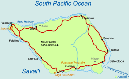
Deutsch: Karte der Insel Savaiʻi, Samoa
English: Map of Savaiʻi Island, Samoa
|
| ⧼wm-license-information-date⧽ | 2009 |
| ⧼wm-license-information-source⧽ | ⧼Wm-license-own-work⧽, based on original from CloudSurfer |
| ⧼wm-license-information-author⧽ | Telim tor |
| ⧼wm-license-information-other-versions⧽ |
ترخيص
|

تاريخ الملف
اضغط على زمن/تاريخ لرؤية الملف كما بدا في هذا الزمن.
| زمن/تاريخ | صورة مصغرة | الأبعاد | مستخدم | تعليق | |
|---|---|---|---|---|---|
| حالي | ★ مراجعة معتمدة 08:39، 12 نوفمبر 2023 | | 416 × 256 (54 كيلوبايت) | Pastakhov (نقاش | مساهمات) | Upload https://upload.wikimedia.org/wikipedia/commons/4/4e/Samoa_Savaii_map.png |
لا يمكنك استبدال هذا الملف.
وصلات
لا يوجد صفحات تصل لهذه الصورة.