ملف:SaintVincentGrenadinenKarte.png
لا توجد دقة أعلى متوفرة.
SaintVincentGrenadinenKarte.png (330 × 355 بكسل حجم الملف: 17 كيلوبايت، نوع MIME: image/png)
| ⧼wm-license-information-description⧽ |
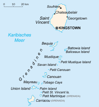
English: Map of the Grenadines from CIA World Factbook. The Grenadines are a Caribbean island chain that belongs to either St. Vincent and the Grenadines or Barbados.
|
||
| ⧼wm-license-information-date⧽ | |||
| ⧼wm-license-information-source⧽ | Central Intelligence Agency's World Factbook | ||
| ⧼wm-license-information-author⧽ | United States Central Intelligence Agency | ||
| ⧼wm-license-information-permission⧽ (⧼wm-license-information-permission-reusing-text⧽) |
|

تاريخ الملف
اضغط على زمن/تاريخ لرؤية الملف كما بدا في هذا الزمن.
| زمن/تاريخ | صورة مصغرة | الأبعاد | مستخدم | تعليق | |
|---|---|---|---|---|---|
| حالي | ★ مراجعة معتمدة 07:02، 9 نوفمبر 2023 | | 330 × 355 (17 كيلوبايت) | Pastakhov (نقاش | مساهمات) | Upload https://upload.wikimedia.org/wikipedia/commons/6/61/SaintVincentGrenadinenKarte.png |
لا يمكنك استبدال هذا الملف.
وصلات
لا يوجد صفحات تصل لهذه الصورة.