ملف:SWE-Map Combo2007Coloured.svg

حجم معاينة PNG لذلك الملف ذي الامتداد SVG: 312 × 598 بكسل. البعد الآخر: 1٬068 × 2٬048 بكسل.
الملف الأصلي (ملف SVG، أبعاده 341 × 654 بكسل، حجم الملف: 287 كيلوبايت)
| ⧼wm-license-information-description⧽ |
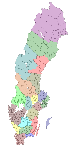
English: Counties and municipalities of Sweden 2007. Note that Heby municipality now is part of Uppsala county. For info on how to easiest edit the map see SWE-Map Documentation
Svenska: Sveriges län och kommuner 2007. Notera att Heby kommun numera tillhör Uppsala län. För information om hur kartan lättast modifieras se SWE-Map Documentation
|
| ⧼wm-license-information-date⧽ | 2007 |
| ⧼wm-license-information-source⧽ | Original borders of the map come from Statistics Sweden (SCB). The maps were edited and modified by Lokal_Profil. |
| ⧼wm-license-information-author⧽ | Lokal_Profil |
| ⧼wm-license-information-permission⧽ (⧼wm-license-information-permission-reusing-text⧽) |
SCB allow free use (including commersial use and derivative work) of their maps (قالب:PermissionTicket). This final result is licensed under |
| ⧼wm-license-information-other-versions⧽ |
|

تاريخ الملف
اضغط على زمن/تاريخ لرؤية الملف كما بدا في هذا الزمن.
| زمن/تاريخ | صورة مصغرة | الأبعاد | مستخدم | تعليق | |
|---|---|---|---|---|---|
| حالي | ★ مراجعة معتمدة 14:57، 11 نوفمبر 2023 | | 341 × 654 (287 كيلوبايت) | Pastakhov (نقاش | مساهمات) | Upload https://upload.wikimedia.org/wikipedia/commons/d/d8/SWE-Map_Combo2007Coloured.svg |
لا يمكنك استبدال هذا الملف.
وصلات
لا يوجد صفحات تصل لهذه الصورة.