ملف:Russian Occupation of Zaporizhzhia Oblast.svg

حجم معاينة PNG لذلك الملف ذي الامتداد SVG: 645 × 600 بكسل. البعد الآخر: 2٬202 × 2٬048 بكسل.
الملف الأصلي (ملف SVG، أبعاده 1٬146 × 1٬066 بكسل، حجم الملف: 329 كيلوبايت)
وصف قصير
| أحداث هذه المقالة هي أحداث جارية. المعلومات المذكورة قد تتغير بسرعة مع تغير الحدث. |
| ⧼wm-license-information-description⧽ |
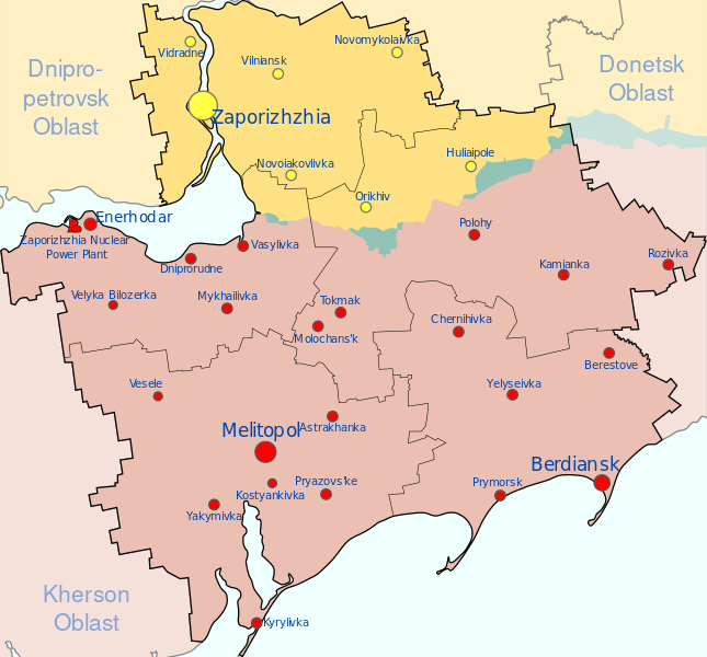
Français : Août 2022 la zone de Zaporijjia, sous contrôle de l'Ukraine ( ), contrôle de la Russie ( )
English: Map of Zaporizhzhia Oblast showing the rough zones of occupation during the southern offensive of the 2022 Russian invasion of Ukraine, as of August 2022.
Ukraine ( ) has maintained control over the north of the oblast, including the areas around the cities of Zaporizhzhia, Huliaipole and Orikhiv. The Russian occupation ( ) extends throughout the entire southern part of the oblast, including the major cities of Melitopol, Berdiansk and Enerhodar. |
| ⧼wm-license-information-date⧽ | 2022 |
| ⧼wm-license-information-source⧽ | ⧼Wm-license-own-work⧽, derivate of قالب:F & قالب:F
|
| ⧼wm-license-information-author⧽ | Physeters |
| ⧼wm-license-information-other-versions⧽ |
ترخيص
|
تاريخ الملف
اضغط على زمن/تاريخ لرؤية الملف كما بدا في هذا الزمن.
| زمن/تاريخ | صورة مصغرة | الأبعاد | مستخدم | تعليق | |
|---|---|---|---|---|---|
| حالي | ★ مراجعة معتمدة 21:54، 1 ديسمبر 2023 | | 1٬146 × 1٬066 (329 كيلوبايت) | Pastakhov (نقاش | مساهمات) | Upload https://upload.wikimedia.org/wikipedia/commons/e/ef/Russian_Occupation_of_Zaporizhzhia_Oblast.svg |
لا يمكنك استبدال هذا الملف.
وصلات
لا يوجد صفحات تصل لهذه الصورة.