ملف:Route Map of Hudson Bay Railway.svg

حجم معاينة PNG لذلك الملف ذي الامتداد SVG: 490 × 600 بكسل. البعد الآخر: 1٬672 × 2٬048 بكسل.
الملف الأصلي (ملف SVG، أبعاده 980 × 1٬200 بكسل، حجم الملف: 20 كيلوبايت)
وصف قصير
| ⧼wm-license-information-description⧽ |
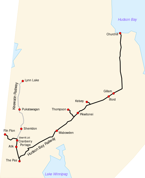
English: Route map of the Hudson Bay Railway and the Keewating Railway.
|
| ⧼wm-license-information-date⧽ | 2008 |
| ⧼wm-license-information-source⧽ | map source is Image:Canada (geolocalisation).svg by STyx, where northern Manitoba map was cropped. Railway lines were added based on the map at http://www.omnitrax.com |
| ⧼wm-license-information-author⧽ | TeVe |
ترخيص
|

.svg&action=edit&redlink=1)
تاريخ الملف
اضغط على زمن/تاريخ لرؤية الملف كما بدا في هذا الزمن.
| زمن/تاريخ | صورة مصغرة | الأبعاد | مستخدم | تعليق | |
|---|---|---|---|---|---|
| حالي | ★ مراجعة معتمدة 17:10، 30 نوفمبر 2023 | | 980 × 1٬200 (20 كيلوبايت) | Pastakhov (نقاش | مساهمات) | Upload https://upload.wikimedia.org/wikipedia/commons/2/21/Route_Map_of_Hudson_Bay_Railway.svg |
لا يمكنك استبدال هذا الملف.
وصلات
لا يوجد صفحات تصل لهذه الصورة.