ملف:Rosary cemetery, Norwich - the chapel (geograph 2101253).jpg
لا توجد دقة أعلى متوفرة.
Rosary_cemetery,_Norwich_-_the_chapel_(geograph_2101253).jpg (640 × 480 بكسل حجم الملف: 154 كيلوبايت، نوع MIME: image/jpeg)
وصف قصير
| ⧼wm-license-information-description⧽ |
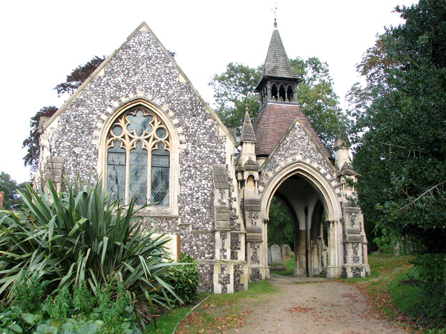
English: Rosary cemetery, Norwich - the chapel. The entrance to the Rosary Cemetery lies on Rosary Road. This was the first ever non-denominational cemetery in the UK, established in 1819 by Thomas Drummond, a nonconformist minister. The land was formerly in use as a market garden, and presents a broad green open space between the housing areas to the south and the playing fields of the Telegraph Lane schools to the north. The cemetery chapel was constructed in 1879 and is believed to be the finest work of architect Edward Boardman.
|
| ⧼wm-license-information-date⧽ | 2010 |
| ⧼wm-license-information-source⧽ | From geograph.org.uk |
| ⧼wm-license-information-author⧽ | Evelyn Simak |
| ⧼wm-license-cc-attribution⧽ (قالب:I18n/Credit line) |
Evelyn Simak / Rosary cemetery, Norwich - the chapel / |
قالب:Location dec قالب:Object location
ترخيص
تاريخ الملف
اضغط على زمن/تاريخ لرؤية الملف كما بدا في هذا الزمن.
| زمن/تاريخ | صورة مصغرة | الأبعاد | مستخدم | تعليق | |
|---|---|---|---|---|---|
| حالي | ★ مراجعة معتمدة 16:39، 2 ديسمبر 2023 | | 640 × 480 (154 كيلوبايت) | Pastakhov (نقاش | مساهمات) | Upload https://upload.wikimedia.org/wikipedia/commons/f/ff/Rosary_cemetery%2C_Norwich_-_the_chapel_%28geograph_2101253%29.jpg |
لا يمكنك استبدال هذا الملف.
وصلات
لا يوجد صفحات تصل لهذه الصورة.
.jpg&oldid=3670534)