ملف:Roman-Persian Frontier in Late Antiquity-ru.svg

حجم معاينة PNG لذلك الملف ذي الامتداد SVG: 800 × 513 بكسل. البعد الآخر: 2٬560 × 1٬642 بكسل.
الملف الأصلي (ملف SVG، أبعاده 2٬718 × 1٬743 بكسل، حجم الملف: 1٫61 ميجابايت)
وصف قصير
| ⧼wm-license-information-description⧽ |
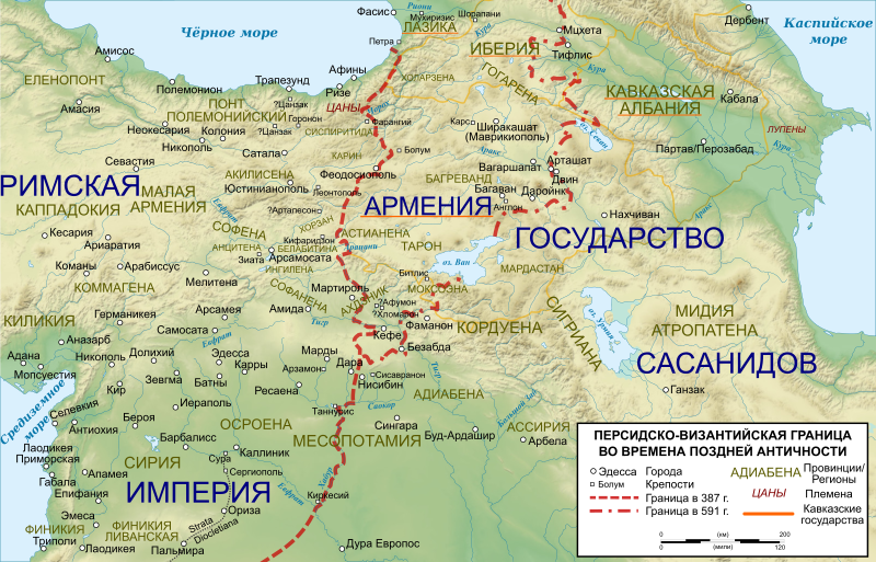
English: The frontier between the Roman/Byzantine and Sassanid Persian empires in Late Antiquity (4th-7th centuries). Basemap taken from Image:Arshakuni Armenia 150-en.svg. Sources: G. Greatrex & S.N.C. Lieu: The Roman Eastern Frontier and the Persian Wars (Part II, 363–630 AD). Routledge 2002, ISBN 0-415-14687-9, pp. xxix–xxxii; R.W. Thomson, J. Howard-Johnston & T. Greenwood: The Armenian history attributed to Sebeos Liverpool University Press 1999, ISBN 0-85323-564-3, pp. 360–363; Map of the cities listed in Hierocles' Synecdemus after Ernest Honigmann, Le Synecdèmos d'Hiéroclès et l'opuscule géographique de Georges de Chypre, Brussels 1939
|
| ⧼wm-license-information-date⧽ | 2015 |
| ⧼wm-license-information-source⧽ | File:Roman-Persian Frontier in Late Antiquity.svg |
| ⧼wm-license-information-author⧽ | Kaidor |
| ⧼wm-license-information-other-versions⧽ |
قالب:Other versions/Roman-Persian Frontier in Late Antiquity |
|
|
This image was created with Inkscape. |
قالب:Translation possible قالب:Graphic Lab
ترخيص
|
تاريخ الملف
اضغط على زمن/تاريخ لرؤية الملف كما بدا في هذا الزمن.
| زمن/تاريخ | صورة مصغرة | الأبعاد | مستخدم | تعليق | |
|---|---|---|---|---|---|
| حالي | ★ مراجعة معتمدة 09:25، 10 أكتوبر 2023 | | 2٬718 × 1٬743 (1٫61 ميجابايت) | Pastakhov (نقاش | مساهمات) | Upload https://upload.wikimedia.org/wikipedia/commons/a/aa/Roman-Persian_Frontier_in_Late_Antiquity-ru.svg |
لا يمكنك استبدال هذا الملف.
وصلات
لا يوجد صفحات تصل لهذه الصورة.
معلومات الصورة (ميتا)
تصنيفات:
- Self-published work
- Maps of the Byzantine Levant
- Maps of the Sassanid Empire
- Maps of the history of Georgia
- SVG maps of the history of Armenia
- SVG maps of the history of Azerbaijan
- Maps of the history of the Caucasus in antiquity
- Maps of Caucasian Albania
- Maps of the Kingdom of Iberia
- Maps showing 6th-century history
- Persian-Roman wars
- Maps of Corduene
- Maps of Sophene
- Maps of Commagene
- SVG maps of the ancient Near East
- Maps of Osrhoene
- Russian-language SVG maps showing history
- Khabur River