ملف:Raymond Hall - Heytesbury - geograph.org.uk - 707153.jpg
لا توجد دقة أعلى متوفرة.
Raymond_Hall_-_Heytesbury_-_geograph.org.uk_-_707153.jpg (640 × 432 بكسل حجم الملف: 365 كيلوبايت، نوع MIME: image/jpeg)
وصف قصير
| ⧼wm-license-information-description⧽ |
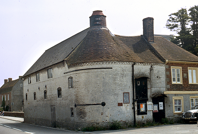
English: Raymond Hall - Heytesbury. A former maltings dating from the late C18, and latterly a disused village hall, although in 1976 when this photo was taken, it was probably still in use as a village hall. The curved end is explained by the fact that it incorporates a circular oast house. Grade II Listed. Compare this image with the modern view thirty years later 541157. Apart from a modern sprucing up, there have also been some small alterations, probably to facilitate its conversion to a private house.
|
| ⧼wm-license-information-date⧽ | 1976 |
| ⧼wm-license-information-source⧽ | From geograph.org.uk |
| ⧼wm-license-information-author⧽ | Ronald Searle |
| ⧼wm-license-cc-attribution⧽ (قالب:I18n/Credit line) |
Ronald Searle / Raymond Hall - Heytesbury / |
51°10′56″N 2°06′40″W / 51.1821°N 2.111°W قالب:Object location
_heading:135)
ترخيص
تاريخ الملف
اضغط على زمن/تاريخ لرؤية الملف كما بدا في هذا الزمن.
| زمن/تاريخ | صورة مصغرة | الأبعاد | مستخدم | تعليق | |
|---|---|---|---|---|---|
| حالي | ★ مراجعة معتمدة 21:55، 9 أكتوبر 2023 | | 640 × 432 (365 كيلوبايت) | Pastakhov (نقاش | مساهمات) | Upload https://upload.wikimedia.org/wikipedia/commons/c/ca/Raymond_Hall_-_Heytesbury_-_geograph.org.uk_-_707153.jpg |
لا يمكنك استبدال هذا الملف.
وصلات
لا يوجد صفحات تصل لهذه الصورة.