ملف:Rail, road and foot - geograph.org.uk - 388350.jpg
لا توجد دقة أعلى متوفرة.
Rail,_road_and_foot_-_geograph.org.uk_-_388350.jpg (640 × 406 بكسل حجم الملف: 128 كيلوبايت، نوع MIME: image/jpeg)
وصف قصير
| ⧼wm-license-information-description⧽ |
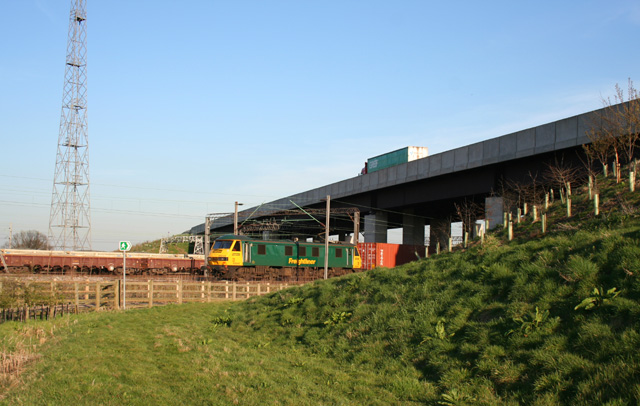
English: Rail, road and foot The A500 dual carriageway bridge over the railway just to the south of Crewe station, with a freight train emerging. Since the construction of the new dual carriageway, the public footpath from Gresty Road in Crewe to Basford has been diverted to go under the railway bridge rather than over the A500 embankment around 200m west. The tower (left) carries lights to illuminate the adjacent Basford Hall Sorting Sidings
|
| ⧼wm-license-information-date⧽ | 2007 |
| ⧼wm-license-information-source⧽ | From geograph.org.uk |
| ⧼wm-license-information-author⧽ | Espresso Addict |
| ⧼wm-license-cc-attribution⧽ (قالب:I18n/Credit line) |
Espresso Addict / Rail, road and foot / |
53°04′14″N 2°25′29″W / 53.07064°N 2.4246°W قالب:Object location
_heading:90)
ترخيص
تاريخ الملف
اضغط على زمن/تاريخ لرؤية الملف كما بدا في هذا الزمن.
| زمن/تاريخ | صورة مصغرة | الأبعاد | مستخدم | تعليق | |
|---|---|---|---|---|---|
| حالي | ★ مراجعة معتمدة 01:19، 20 يناير 2024 | | 640 × 406 (128 كيلوبايت) | Pastakhov (نقاش | مساهمات) | Upload https://upload.wikimedia.org/wikipedia/commons/c/cb/Rail%2C_road_and_foot_-_geograph.org.uk_-_388350.jpg |
لا يمكنك استبدال هذا الملف.
وصلات
لا يوجد صفحات تصل لهذه الصورة.