ملف:Polish-Lithuanian Commonwealth at its maximum extent-es.svg

حجم معاينة PNG لذلك الملف ذي الامتداد SVG: 762 × 599 بكسل. البعد الآخر: 2٬560 × 2٬014 بكسل.
الملف الأصلي (ملف SVG، أبعاده 1٬410 × 1٬109 بكسل، حجم الملف: 147 كيلوبايت)
وصف قصير
| ⧼wm-license-information-description⧽ |
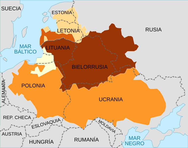
English: A map showing the Polish-Lithuanian Commonwealth at its maximum extent following the Truce of Deulino, superimposed on present-day national borders. The map shows all of the territory that was ruled by Zygmunt III Waza in 1619 (the Polish monarch at that time), which made up the Commonwealth; it can be further divided up into:
Kingdom of Poland
Duchy of Prussia, Polish fief
Grand Duchy of Lithuania
Duchy of Courland, Lithuanian fief
Livonia |
| ⧼wm-license-information-date⧽ | 2016 |
| ⧼wm-license-information-source⧽ | قالب:F قالب:F |
| ⧼wm-license-information-author⧽ | قالب:F: خطأ: لا توجد وحدة بهذا الاسم "user".
قالب:F: خطأ: لا توجد وحدة بهذا الاسم "user". |
ترخيص
|
|
هذا الملفُّ مُرخَّص بموجب رخصة المشاع الإبداعي نسبة المُصنَّف إِلى مؤلفه - المشاركة بالمثل 3.0 العامة. |
تاريخ الملف
اضغط على زمن/تاريخ لرؤية الملف كما بدا في هذا الزمن.
| زمن/تاريخ | صورة مصغرة | الأبعاد | مستخدم | تعليق | |
|---|---|---|---|---|---|
| حالي | ★ مراجعة معتمدة 21:36، 17 ديسمبر 2023 | | 1٬410 × 1٬109 (147 كيلوبايت) | Pastakhov (نقاش | مساهمات) | Upload https://upload.wikimedia.org/wikipedia/commons/4/42/Polish-Lithuanian_Commonwealth_at_its_maximum_extent-es.svg |
لا يمكنك استبدال هذا الملف.
وصلات
لا يوجد صفحات تصل لهذه الصورة.