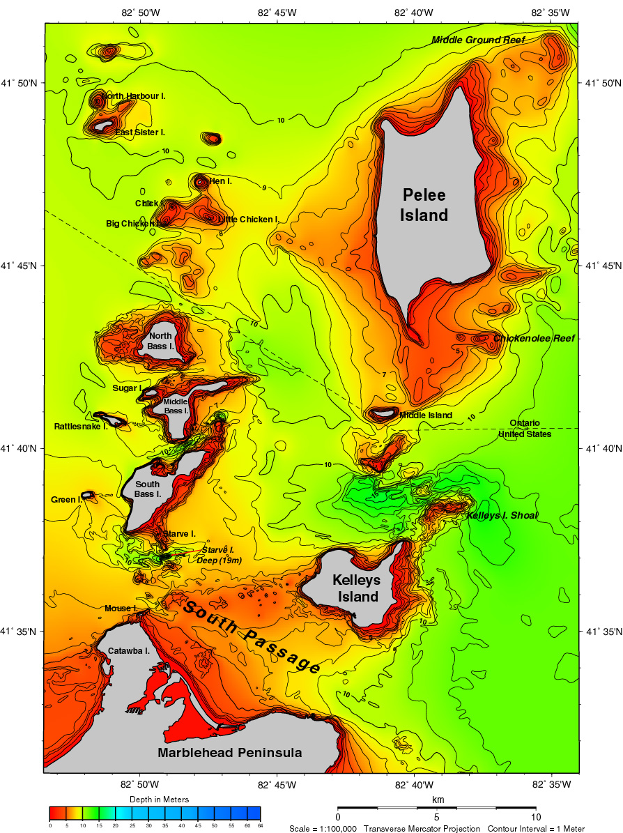
ملف:Pelee and nearby islands in Lake Erie.jpg
حجم هذه المعاينة: 448 × 599 بكسل. البعد الآخر: 894 × 1٬195 بكسل.
الملف الأصلي (894 × 1٬195 بكسل حجم الملف: 643 كيلوبايت، نوع MIME: image/jpeg)
| ⧼wm-license-information-description⧽ |
Islands in Lake Erie |
||
| ⧼wm-license-information-date⧽ | |||
| ⧼wm-license-information-source⧽ | https://www.ngdc.noaa.gov/mgg/greatlakes/lakeerie_cdrom/html/e_area7.htm | ||
| ⧼wm-license-information-author⧽ | |||
| ⧼wm-license-information-permission⧽ (⧼wm-license-information-permission-reusing-text⧽) |
|

تاريخ الملف
اضغط على زمن/تاريخ لرؤية الملف كما بدا في هذا الزمن.
| زمن/تاريخ | صورة مصغرة | الأبعاد | مستخدم | تعليق | |
|---|---|---|---|---|---|
| حالي | ★ مراجعة معتمدة 06:06، 16 ديسمبر 2023 | | 894 × 1٬195 (643 كيلوبايت) | Pastakhov (نقاش | مساهمات) | Upload https://upload.wikimedia.org/wikipedia/commons/d/db/Pelee_and_nearby_islands_in_Lake_Erie.jpg |
لا يمكنك استبدال هذا الملف.
وصلات
لا يوجد صفحات تصل لهذه الصورة.
تصنيفات:
- National Oceanic and Atmospheric Administration images
- Bathymetric maps of Lake Erie
- Maps of Pelee Island
- Rattlesnake Island (Lake Erie)
- Middle Bass Island
- Maps of Kelleys Island, Ohio
- Maps of South Bass Island
- North Bass Island
- Sugar Island (Michigan)
- Green Island (Lake Erie)
- Starve Island
- Big Chicken Island
- Little Chicken Island
- Mouse Island (Ohio)
- Middle Island (Lake Erie)
- Chick Island
- Hen Island
- Marblehead Peninsula (Ohio)
- North Harbour Island
- East Sister Island
- Bathymetric maps of the Great Lakes