ملف:Panganirivermap.png

حجم هذه المعاينة: 575 × 600 بكسل. البعد الآخر: 1٬000 × 1٬043 بكسل.
الملف الأصلي (1٬000 × 1٬043 بكسل حجم الملف: 858 كيلوبايت، نوع MIME: image/png)
وصف قصير
| ⧼wm-license-information-description⧽ |
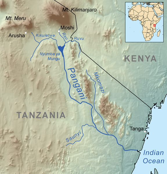
Map showing the Pangani River. |
| ⧼wm-license-information-date⧽ | 2011 |
| ⧼wm-license-information-source⧽ | ⧼Wm-license-own-work⧽, Elevation data from SRTM, all other features from Natural Earth. Pangani Project and U.S. Army Map Service used as references. |
| ⧼wm-license-information-author⧽ | Kmusser |
ترخيص
|
تاريخ الملف
اضغط على زمن/تاريخ لرؤية الملف كما بدا في هذا الزمن.
| زمن/تاريخ | صورة مصغرة | الأبعاد | مستخدم | تعليق | |
|---|---|---|---|---|---|
| حالي | ★ مراجعة معتمدة 22:36، 16 أكتوبر 2023 | | 1٬000 × 1٬043 (858 كيلوبايت) | Pastakhov (نقاش | مساهمات) | Upload https://upload.wikimedia.org/wikipedia/commons/4/4d/Panganirivermap.png |
لا يمكنك استبدال هذا الملف.
وصلات
لا يوجد صفحات تصل لهذه الصورة.