ملف:Paleo-Veneti map.PNG
لا توجد دقة أعلى متوفرة.
Paleo-Veneti_map.PNG (589 × 356 بكسل حجم الملف: 321 كيلوبايت، نوع MIME: image/png)
| ⧼wm-license-information-description⧽ |
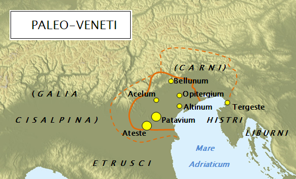
English: Map of Paleo-Veneti. Based on texts and maps in: Adams Douglas Q., Mallory J. P. (1997): Encyclopedia of Indo-European culture. USA, Fitzroy Dearborn Publishers. Page 183; Božič et al (1998). Zakladi tisočletij: Zgodovina Slovenije od neandertalcev do Slovanov. Ljubljana, Modrijan. Page 103, 150, 179; Makarovič Jan. (1998). Od Črne boginje do Sina Božjega. Ljubljana/Pisa, Studi Slavi & FDV. Page 36; Wilkes John (1992): The Illyrians. USA, Blackwell Publishers. Page 183-184.
|
| ⧼wm-license-information-date⧽ | 2010-06-11 09:29 (UTC) |
| ⧼wm-license-information-source⧽ | |
| ⧼wm-license-information-author⧽ |
|
| [This is a retouched picture, which means that it has been digitally altered from its original version. Modifications: Part of the original map was used to create a new historical map.. The original can be viewed here: Topographic_map_of_Italy.jpg. Modifications made by Bostjan46.] Error: {{Lang}}: text has italic markup (help)
|
قالب:Original upload log
This image is a derivative work of the following images:
- File:Topographic_map_of_Italy.jpg licensed with PD-user
- 2010-04-04T13:13:08Z F l a n k e r 1544x1783 (450034 Bytes) Reverted to version as of 00:07, 24 January 2008
- 2010-04-01T21:18:10Z Gigillo83 1544x1783 (1980110 Bytes) Borders
- 2010-04-01T21:16:16Z Gigillo83 1544x1783 (71230 Bytes) Italian Borders
- 2008-01-24T00:07:34Z F l a n k e r 1544x1783 (450034 Bytes) {{Information |Description=Topographic map of Italy |Source=[http://www2.jpl.nasa.gov/srtm NASA Shuttle Radar Topography Mission] (SRTM3 v.2) (public domain) edited with [http://www.visualizationsoftware.com/3dem.html 3DEM] f
تاريخ الملف
اضغط على زمن/تاريخ لرؤية الملف كما بدا في هذا الزمن.
| زمن/تاريخ | صورة مصغرة | الأبعاد | مستخدم | تعليق | |
|---|---|---|---|---|---|
| حالي | ★ مراجعة معتمدة 08:52، 19 أكتوبر 2023 | | 589 × 356 (321 كيلوبايت) | Pastakhov (نقاش | مساهمات) | Upload https://upload.wikimedia.org/wikipedia/commons/9/93/Paleo-Veneti_map.PNG |
لا يمكنك استبدال هذا الملف.
وصلات
لا يوجد صفحات تصل لهذه الصورة.