ملف:New england ref 2001.jpg

حجم هذه المعاينة: 396 × 599 بكسل. البعد الآخر: 900 × 1٬361 بكسل.
الملف الأصلي (900 × 1٬361 بكسل حجم الملف: 385 كيلوبايت، نوع MIME: image/jpeg)
وصف قصير
| ⧼wm-license-information-description⧽ |
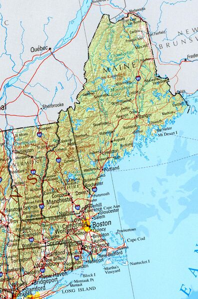
Reference Map of New England, including Vermont, Maine, New Hampshire, Massachusetts, Connecticut, Rhode Island. University of Texas, Perry-Castañeda Library Map Collection, Vermont Maps Shaded relief map with state boundaries, forest cover, place names, major highways. Portion of "The National Atlas of the United States of America. General Reference", compiled by U.S. Geological Survey 2001, printed 2002 |
| ⧼wm-license-information-date⧽ | Survey 2001 printed 2002 (2004 (according to Exif data)) |
| ⧼wm-license-information-source⧽ | http://www.lib.utexas.edu/maps/us_2001/new_england_ref_2001.jpg |
| ⧼wm-license-information-author⧽ |
ترخيص
تاريخ الملف
اضغط على زمن/تاريخ لرؤية الملف كما بدا في هذا الزمن.
| زمن/تاريخ | صورة مصغرة | الأبعاد | مستخدم | تعليق | |
|---|---|---|---|---|---|
| حالي | ★ مراجعة معتمدة 21:00، 14 يناير 2024 | | 900 × 1٬361 (385 كيلوبايت) | Pastakhov (نقاش | مساهمات) | Upload https://upload.wikimedia.org/wikipedia/commons/7/7f/New_england_ref_2001.jpg |
لا يمكنك استبدال هذا الملف.
وصلات
لا يوجد صفحات تصل لهذه الصورة.