ملف:Netherlands, Leiderdorp, map of 1867.png

الملف الأصلي (2٬448 × 2٬048 بكسل حجم الملف: 7٫52 ميجابايت، نوع MIME: image/png)
وصف قصير
| ⧼wm-license-information-description⧽ |
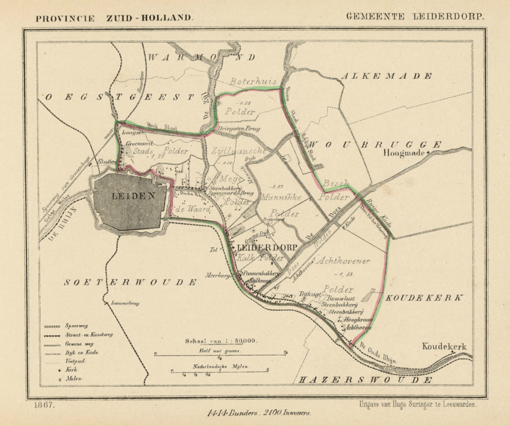
(Dutch) English: Map of 1867 of the municipality of Leiderdorp (close to the town of Leiden, Province of South Holland, Netherlands). Leiderdorp still exists as a separate municipality (2011).
|
| ⧼wm-license-information-date⧽ | Published as part of a series of provincial atlases of the Netherlands between 1865-1870. |
| ⧼wm-license-information-source⧽ | Gemeente-atlas van Nederland naar officieele bronnen bewerkt. |
| ⧼wm-license-information-author⧽ | J. Kuyper |
| ⧼wm-license-information-permission⧽ (⧼wm-license-information-permission-reusing-text⧽) |
This image is in the public domain. The author J. Kuyper died in 1908. [In the Netherlands copyright expires 70 years after the death of the author or 70 years after first publication in the case of anonymous or pseudonymous works or works published by a legal entity]. [Het auteursrecht in Nederland vervalt 70 jaar na de dood van de auteur of 70 jaar na de eerste openbaarmaking van het werk, indien het gaat om een anoniem of om een onder pseudoniem verschenen werk of werk van een rechtspersoon]. |
Leiderdorp's church as indicated on the map, is located at: 52°9′3.47″N 4°31′24.57″E / 52.1509639°N 4.5234917°E
ترخيص
|
هذه الصورة هي ضمن الملكية عامة بسبب إنتهاء فترة صلاحية حقوقها في الولايات المتحدة الأمريكية و أي دولة أخرى ينص قانونها على مرور 70 سنة كحد أعلى على وفاة المنتج لإنتهاء صلاحية الحقوق.
The official position taken by the Wikimedia Foundation is that "faithful reproductions of two-dimensional public domain works of art are public domain, and that claims to the contrary represent an assault on the very concept of a public domain". For details, see Commons:When to use the PD-Art tag.
|
تاريخ الملف
اضغط على زمن/تاريخ لرؤية الملف كما بدا في هذا الزمن.
| زمن/تاريخ | صورة مصغرة | الأبعاد | مستخدم | تعليق | |
|---|---|---|---|---|---|
| حالي | ★ مراجعة معتمدة 02:03، 15 نوفمبر 2023 | | 2٬448 × 2٬048 (7٫52 ميجابايت) | Pastakhov (نقاش | مساهمات) | Upload https://upload.wikimedia.org/wikipedia/commons/f/fe/Netherlands%2C_Leiderdorp%2C_map_of_1867.png |
لا يمكنك استبدال هذا الملف.
وصلات
لا يوجد صفحات تصل لهذه الصورة.