ملف:NWCoast1a.png

NWCoast1a.png (761 × 529 بكسل حجم الملف: 172 كيلوبايت، نوع MIME: image/png)

|
[All images in this gallery should be recreated using vector graphics as an SVG file. This has several advantages; see Commons:Media for cleanup for more information. If an SVG form of this image is already available, please upload it. After uploading an SVG, replace this template with {{vector version available|new image name.svg}}.] Error: {{Lang}}: text has italic markup (help) |
|
العربية | български | català | čeština | dansk | Deutsch | English | Esperanto | español | français | galego | 한국어 | italiano | magyar | lietuvių | 日本語 | Plattdüütsch | Nederlands | norsk | polski | português | română | русский | suomi | svenska | Türkçe | українська | 中文(繁體) | 中文(简体) | +/− | |
وصف قصير
| ⧼wm-license-information-description⧽ |
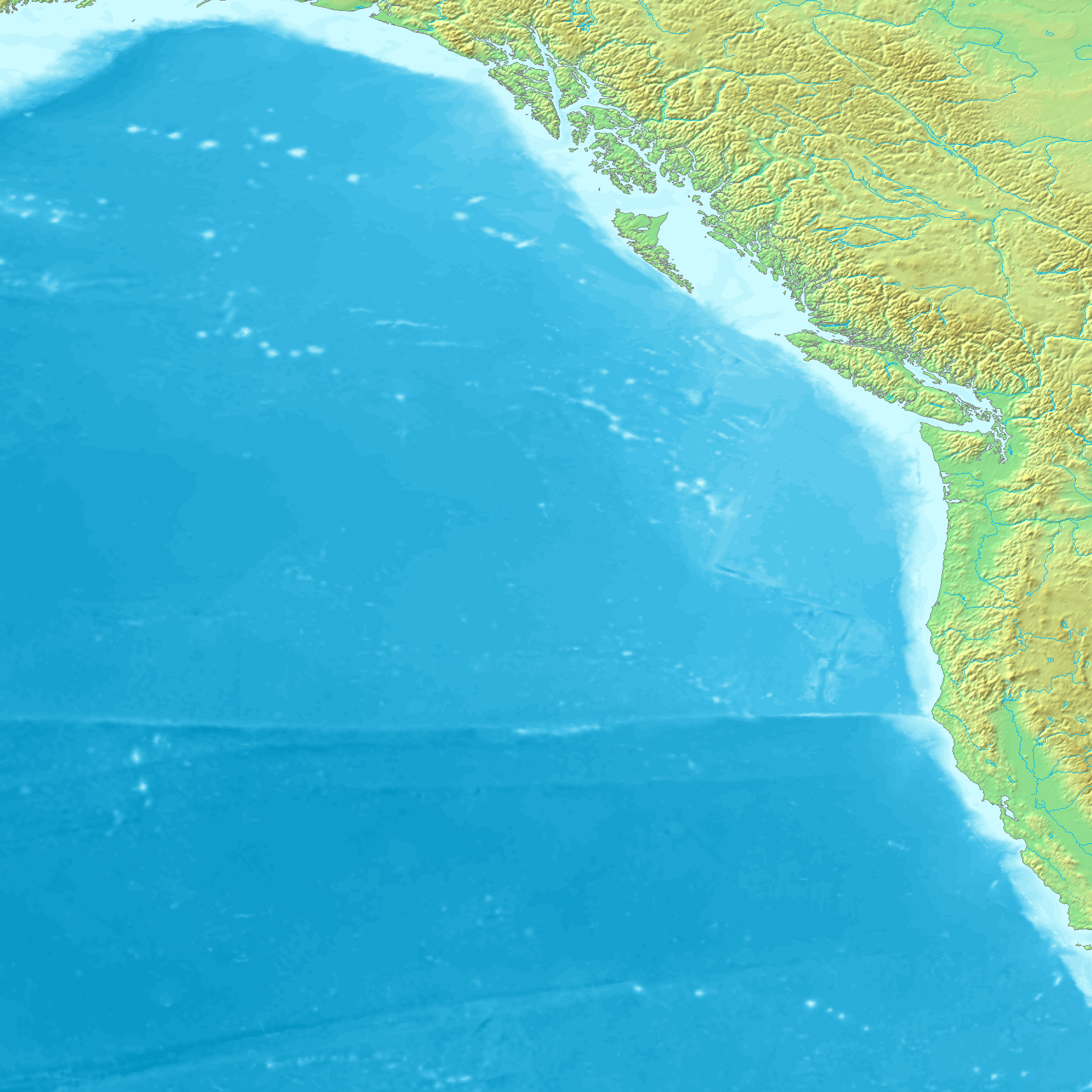
Map of the coast of the Pacific Northwest --- Islands and major straits of the northern American pacific coast showing Prince of Wales Island (Alaska), Queen Charlotte Sound (Canada), Dixon Entrance, Hecate Strait, Baranof Island, Chichagof Island, Juneau Icefield, Stikine Icecap and other |
| ⧼wm-license-information-date⧽ | |
| ⧼wm-license-information-source⧽ | http://en.wikipedia.org/wiki/Image:NWCoast1a.png — — — This is adapted from a regional Topographic map made from GEMS data that is already posted on Wikimedia Commons. Original map created from DEMIS Mapserver, which are public domain. |
| ⧼wm-license-information-author⧽ | en:User:Koba-chan |
ترخيص

|
تاريخ الملف
اضغط على زمن/تاريخ لرؤية الملف كما بدا في هذا الزمن.
| زمن/تاريخ | صورة مصغرة | الأبعاد | مستخدم | تعليق | |
|---|---|---|---|---|---|
| حالي | ★ مراجعة معتمدة 15:31، 29 أكتوبر 2023 | | 761 × 529 (172 كيلوبايت) | Pastakhov (نقاش | مساهمات) | Upload https://upload.wikimedia.org/wikipedia/commons/5/56/NWCoast1a.png |
لا يمكنك استبدال هذا الملف.
وصلات
لا يوجد صفحات تصل لهذه الصورة.
معلومات الصورة (ميتا)
- Map images that should use vector graphics
- Maps of Alaska Panhandle
- Maps of the Alexander Archipelago
- Maps of Haida Gwaii
- Maps of Hecate Strait
- Maps of Dixon Entrance
- Topographic maps of Alaska
- Topographic maps of British Columbia
- Topographic maps of Yukon
- Uploads by Mattes from external sources
- File uploads by User:Mattes (flat)
- Queen Charlotte Sound (Canada)
- Baranof Island
- Stikine Country