ملف:Municipalities Bezirk Mödling.svg

حجم معاينة PNG لذلك الملف ذي الامتداد SVG: 439 × 294 بكسل. البعد الآخر: 2٬560 × 1٬714 بكسل.
الملف الأصلي (ملف SVG، أبعاده 439 × 294 بكسل، حجم الملف: 189 كيلوبايت)
وصف قصير
| ⧼wm-license-information-description⧽ |
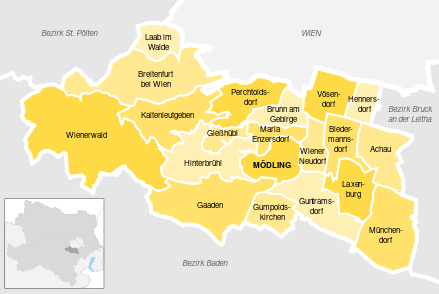
Deutsch: Darstellung aller Gemeinden des Bezirks inklusiver angrenzender Gebietskörperschaften, ausgewählter Gewässer und Hervorhebung des Hauptortes. English: All municipalities of the district including bordering districts and states, rivers and lakes. The capitol is highlighted.
|
| ⧼wm-license-information-date⧽ | 2022 |
| ⧼wm-license-information-source⧽ | Deutsch: Eigenes Werk, basierend auf File:AT_-_blank_-_all_layers.svg von Colazivi, Autriche hydro-de.svg von Pymouss44 und Daten von openstreetmap English: Own work, based on File:AT_-_blank_-_all_layers.svg by Colazivi, Autriche hydro-de.svg by Pymouss44 and data from openstreetmap |
| ⧼wm-license-information-author⧽ | Gnlpfth12 |
ترخيص
|
تاريخ الملف
اضغط على زمن/تاريخ لرؤية الملف كما بدا في هذا الزمن.
| زمن/تاريخ | صورة مصغرة | الأبعاد | مستخدم | تعليق | |
|---|---|---|---|---|---|
| حالي | ★ مراجعة معتمدة 11:23، 1 نوفمبر 2023 | | 439 × 294 (189 كيلوبايت) | Pastakhov (نقاش | مساهمات) | Upload https://upload.wikimedia.org/wikipedia/commons/3/31/Municipalities_Bezirk_M%C3%B6dling.svg |
لا يمكنك استبدال هذا الملف.
وصلات
لا يوجد صفحات تصل لهذه الصورة.