ملف:Montgomery, Alabama Metropolitan Statistical Area.svg

حجم معاينة PNG لذلك الملف ذي الامتداد SVG: 377 × 599 بكسل. البعد الآخر: 1٬288 × 2٬048 بكسل.
الملف الأصلي (ملف SVG، أبعاده 558 × 887 بكسل، حجم الملف: 115 كيلوبايت)
| ⧼wm-license-information-description⧽ |
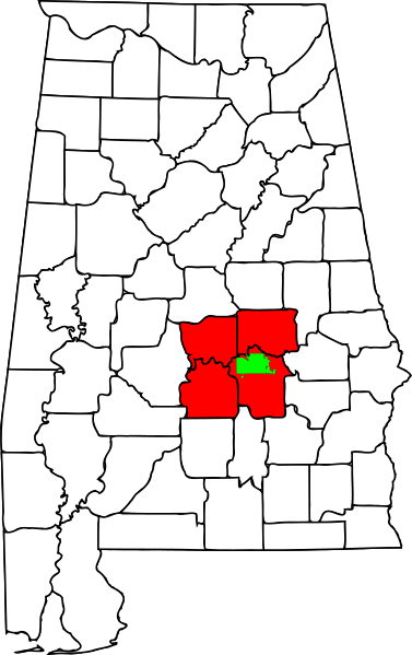
English: Map showing the Montgomery, Alabama, Metropolitan Statistical Area
|
||
| ⧼wm-license-information-date⧽ | 2009 | ||
| ⧼wm-license-information-source⧽ | self made; based on File:Montgomery County Alabama Incorporated and Unincorporated areas Montgomery Highlighted.svg by User:Shereth | ||
| ⧼wm-license-information-author⧽ | Chris Pruitt | ||
| ⧼wm-license-information-permission⧽ (⧼wm-license-information-permission-reusing-text⧽) |
|
|
|
This image was created with Inkscape. |
تاريخ الملف
اضغط على زمن/تاريخ لرؤية الملف كما بدا في هذا الزمن.
| زمن/تاريخ | صورة مصغرة | الأبعاد | مستخدم | تعليق | |
|---|---|---|---|---|---|
| حالي | ★ مراجعة معتمدة 09:32، 26 يناير 2024 | | 558 × 887 (115 كيلوبايت) | Pastakhov (نقاش | مساهمات) | Upload https://upload.wikimedia.org/wikipedia/commons/4/41/Montgomery%2C_Alabama_Metropolitan_Statistical_Area.svg |
لا يمكنك استبدال هذا الملف.
وصلات
لا يوجد صفحات تصل لهذه الصورة.