ملف:Mississippi Alluvial Plain and Mississippi Valley Loess Plains ecoregion, Level III.png
لا توجد دقة أعلى متوفرة.
Mississippi_Alluvial_Plain_and_Mississippi_Valley_Loess_Plains_ecoregion,_Level_III.png (329 × 388 بكسل حجم الملف: 99 كيلوبايت، نوع MIME: image/png)
وصف قصير
| ⧼wm-license-information-description⧽ |
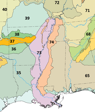
English: Map showing the Mississippi Alluvial Plain (73) and Mississippi Valley Loess Plains (74) ecoregions as defined by USEPA, with adjacent Level III ecoregions
|
| ⧼wm-license-information-date⧽ | 2018 |
| ⧼wm-license-information-source⧽ | File:Level III ecoregions, United States.png |
| ⧼wm-license-information-author⧽ | Original File: United States Environmental Protection Agency Derivative work: User:Brandonrush |
ترخيص
قالب:PD-USGov-EPA Derivative work: قالب:Cc-zero
تاريخ الملف
اضغط على زمن/تاريخ لرؤية الملف كما بدا في هذا الزمن.
| زمن/تاريخ | صورة مصغرة | الأبعاد | مستخدم | تعليق | |
|---|---|---|---|---|---|
| حالي | ★ مراجعة معتمدة 12:03، 26 ديسمبر 2023 | | 329 × 388 (99 كيلوبايت) | Pastakhov (نقاش | مساهمات) | Upload https://upload.wikimedia.org/wikipedia/commons/4/47/Mississippi_Alluvial_Plain_and_Mississippi_Valley_Loess_Plains_ecoregion%2C_Level_III.png |
لا يمكنك استبدال هذا الملف.
وصلات
لا يوجد صفحات تصل لهذه الصورة.
معلومات الصورة (ميتا)
تصنيفات:
- Maps of Arkansas
- Maps of Mississippi (state)
- Maps of Louisiana
- Maps of Missouri
- Maps of Tennessee
- Maps of EPA ecoregions
- Maps of Kentucky
- Ecology in Arkansas
- Ecology in Mississippi (state)
- Ecology in Louisiana
- Ecology in Missouri
- Ecology in Tennessee
- Ecology in Kentucky
- Loess in the United States
- Mississippi River Valley
- PNG maps
- 2018 maps of the United States