ملف:Merseyrail map 2010.svg

حجم معاينة PNG لذلك الملف ذي الامتداد SVG: 551 × 600 بكسل. البعد الآخر: 1٬882 × 2٬048 بكسل.
الملف الأصلي (ملف SVG، أبعاده 1٬226 × 1٬334 بكسل، حجم الملف: 735 كيلوبايت)
وصف قصير
| ⧼wm-license-information-description⧽ |
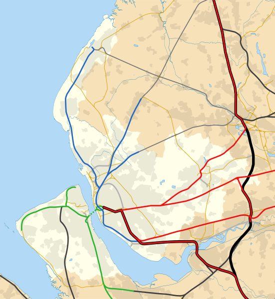
English: Map of Merseyside, England with the following information shown:
Equirectangular map projection on WGS 84 datum, with N/S stretched Geographic limits:
National Rail primary route
National Rail secondary route
National Rail rural route
Goods only
Disused railway |
| ⧼wm-license-information-date⧽ | 2015 |
| ⧼wm-license-information-source⧽ | قالب:Derived from |
| ⧼wm-license-information-author⧽ |
|
References
- (1929) Combined index shewing parishes and the Ordnance Survey of Lancashire Archive copy at the Internet Archive, Ordnance Survey, copy online at Lancashire County Council website accessed 22 July 2012
- Wignall, C.J. (1983), Complete British Railways Maps and Gazetteer from 1830–1981, Oxford Railway Publishing Company, Oxford, ISBN 0 86093 162 5
- (2011) Network Specification 2011 – London North Western Archive copy at the Internet Archive, Network Rail, London, p.24, accessed 23 July 2012
- (1947–1957) Ordnance Survey New Popular Edition maps, copy online at New Popular Edition Maps website, accessed 14 August 2012
- (2009) Merseyrail network map, Merseytravel website, accessed 19 February 2015
ترخيص
|
|
هذا الملفُّ مُرخَّص بموجب رخصة المشاع الإبداعي نسبة المُصنَّف إِلى مؤلفه - المشاركة بالمثل 3.0 العامة. |
تاريخ الملف
اضغط على زمن/تاريخ لرؤية الملف كما بدا في هذا الزمن.
| زمن/تاريخ | صورة مصغرة | الأبعاد | مستخدم | تعليق | |
|---|---|---|---|---|---|
| حالي | ★ مراجعة معتمدة 10:36، 13 نوفمبر 2023 | | 1٬226 × 1٬334 (735 كيلوبايت) | Pastakhov (نقاش | مساهمات) | Upload https://upload.wikimedia.org/wikipedia/commons/d/dc/Merseyrail_map_2010.svg |
لا يمكنك استبدال هذا الملف.
وصلات
لا يوجد صفحات تصل لهذه الصورة.