ملف:Maybole Town Hall - geograph.org.uk - 1212766.jpg
لا توجد دقة أعلى متوفرة.
Maybole_Town_Hall_-_geograph.org.uk_-_1212766.jpg (421 × 600 بكسل حجم الملف: 56 كيلوبايت، نوع MIME: image/jpeg)
وصف قصير
| ⧼wm-license-information-description⧽ |
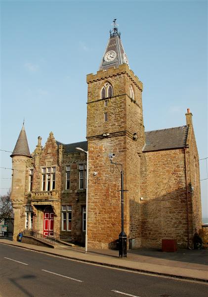
English: Maybole Town Hall This building started as a castle, built during the 17th century as a town house for the lairds of nearby Blairquhan. By the middle of the century, it was in use as a Tolbooth and jail. The 19th century Town Hall, dated 1887, was built around the Tolbooth. (Source: "Maybole - Carrick's Capital", by James T Gray).
|
| ⧼wm-license-information-date⧽ | 2009 |
| ⧼wm-license-information-source⧽ | From geograph.org.uk |
| ⧼wm-license-information-author⧽ | Mary and Angus Hogg |
| ⧼wm-license-cc-attribution⧽ (قالب:I18n/Credit line) |
Mary and Angus Hogg / Maybole Town Hall / |
55°21′12″N 4°41′01″W / 55.35329°N 4.6835°W قالب:Object location
_heading:112)
ترخيص
تاريخ الملف
اضغط على زمن/تاريخ لرؤية الملف كما بدا في هذا الزمن.
| زمن/تاريخ | صورة مصغرة | الأبعاد | مستخدم | تعليق | |
|---|---|---|---|---|---|
| حالي | ★ مراجعة معتمدة 14:23، 11 نوفمبر 2023 | | 421 × 600 (56 كيلوبايت) | Pastakhov (نقاش | مساهمات) | Upload https://upload.wikimedia.org/wikipedia/commons/0/0a/Maybole_Town_Hall_-_geograph.org.uk_-_1212766.jpg |
لا يمكنك استبدال هذا الملف.
وصلات
لا يوجد صفحات تصل لهذه الصورة.