ملف:Mataram Sultanate in Sultan Agung Reign.svg

حجم معاينة PNG لذلك الملف ذي الامتداد SVG: 800 × 295 بكسل. البعد الآخر: 2٬560 × 944 بكسل.
الملف الأصلي (ملف SVG، أبعاده 2٬053 × 757 بكسل، حجم الملف: 284 كيلوبايت)
وصف قصير
| ⧼wm-license-information-description⧽ |
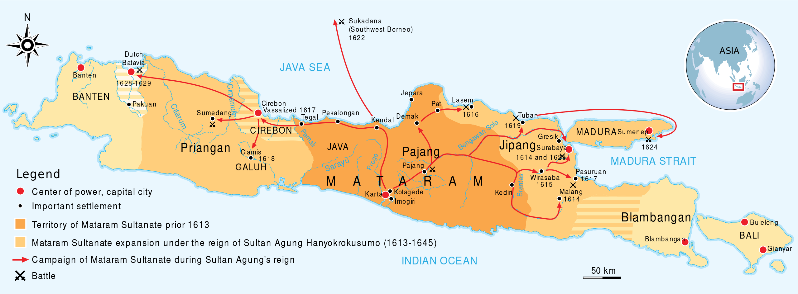
English: The maximum extent of Mataram Sultanate expansions during the reign of Sultan Agung Hanyokrokusumo (1613-1645). During his reign he expanded the Mataram Sultanate throughout in Central Java, East Java (with exceptions of Blambangan area in extreme East), half of Western Java (except Banten Sultanate area and Batavia Dutch settlement).
|
|||||
| ⧼wm-license-information-date⧽ | 2011 | |||||
| ⧼wm-license-information-source⧽ | ⧼Wm-license-own-work⧽ redrawed based on the map in "Historical Atlas of Indonesia and the World" , Pembina (1996) | |||||
| ⧼wm-license-information-author⧽ | Gunawan Kartapranata | |||||
| ⧼wm-license-information-permission⧽ (⧼wm-license-information-permission-reusing-text⧽) |
|
|||||
| ⧼wm-license-information-other-versions⧽ |
|

تاريخ الملف
اضغط على زمن/تاريخ لرؤية الملف كما بدا في هذا الزمن.
| زمن/تاريخ | صورة مصغرة | الأبعاد | مستخدم | تعليق | |
|---|---|---|---|---|---|
| حالي | ★ مراجعة معتمدة 23:05، 29 أكتوبر 2023 | 2٬053 × 757 (284 كيلوبايت) | Pastakhov (نقاش | مساهمات) | Upload https://upload.wikimedia.org/wikipedia/commons/a/a3/Mataram_Sultanate_in_Sultan_Agung_Reign.svg |
لا يمكنك استبدال هذا الملف.
وصلات
الصفحات التالية تحتوي على وصلة لهذه الصورة: