ملف:Marycolony.png
لا توجد دقة أعلى متوفرة.
Marycolony.png (483 × 433 بكسل حجم الملف: 28 كيلوبايت، نوع MIME: image/png)
وصف قصير
| ⧼wm-license-information-description⧽ |
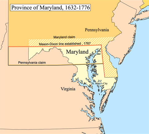
English: Map of the Province of Maryland.
Boundary disputes between colonies not involving Maryland are not shown. |
| ⧼wm-license-information-date⧽ | 2006 |
| ⧼wm-license-information-source⧽ | Karl Musser |
| ⧼wm-license-information-author⧽ | Karl Musser |
ترخيص
|
تاريخ الملف
اضغط على زمن/تاريخ لرؤية الملف كما بدا في هذا الزمن.
| زمن/تاريخ | صورة مصغرة | الأبعاد | مستخدم | تعليق | |
|---|---|---|---|---|---|
| حالي | ★ مراجعة معتمدة 19:58، 10 نوفمبر 2023 | | 483 × 433 (28 كيلوبايت) | Pastakhov (نقاش | مساهمات) | Upload https://upload.wikimedia.org/wikipedia/commons/a/a9/Marycolony.png |
لا يمكنك استبدال هذا الملف.
وصلات
لا يوجد صفحات تصل لهذه الصورة.