ملف:Map of the clans of Scotland (1899, third edition).jpg
حجم هذه المعاينة: 460 × 600 بكسل. البعدان الآخران: 1٬571 × 2٬048 بكسل | 3٬505 × 4٬568 بكسل.
الملف الأصلي (3٬505 × 4٬568 بكسل حجم الملف: 5٫68 ميجابايت، نوع MIME: image/jpeg)
وصف قصير
| ⧼wm-license-information-description⧽ |
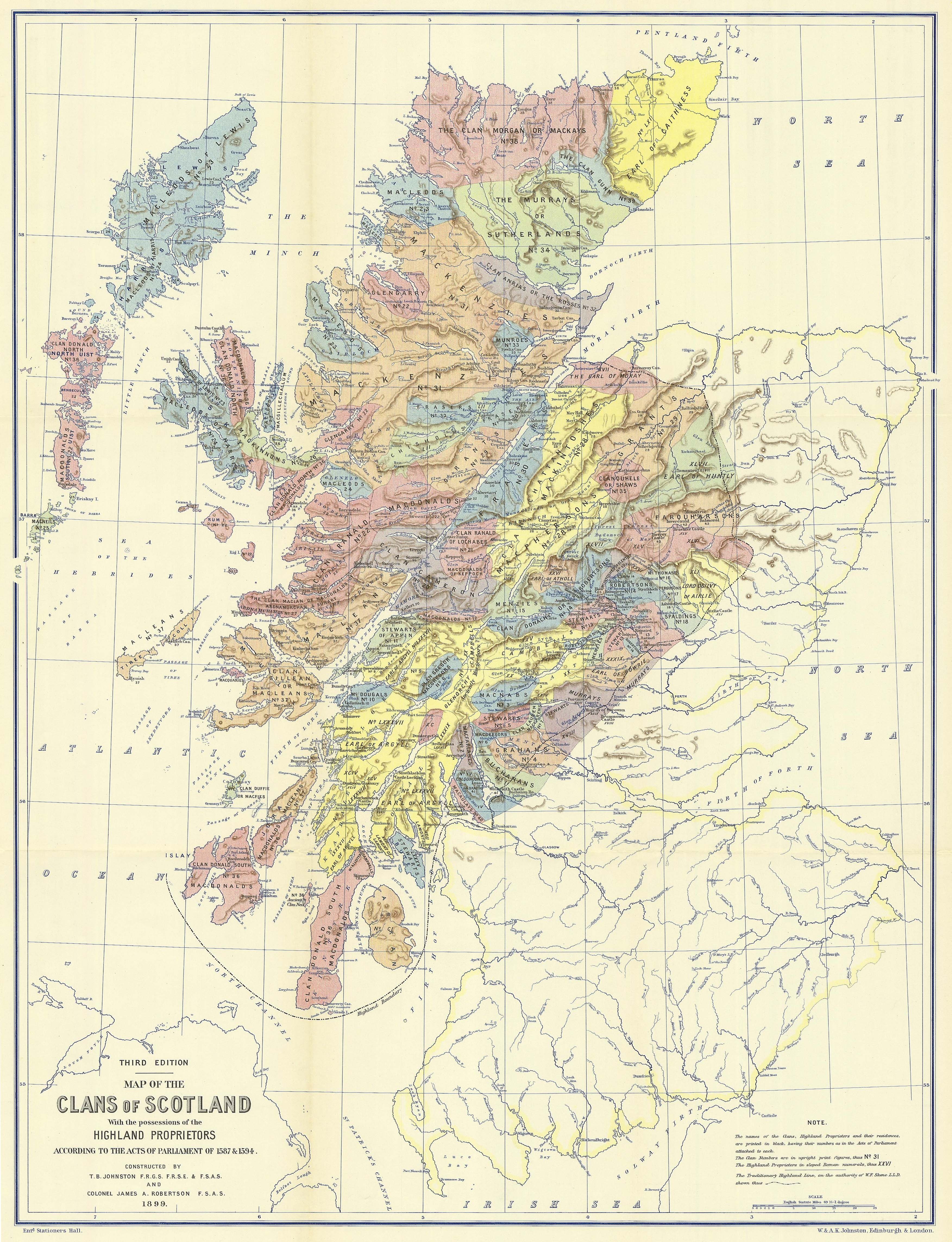
Titled "Map of the clans of Scotland with the possessions of the Highland Proprietors according to the Acts of Parliament of 1587 & 1594". The map shows the locations of the clans and the land owned by the principal landowners in around 1587-1594. The map was created in the late 1800s and published in 1899. |
| ⧼wm-license-information-date⧽ | 1899 |
| ⧼wm-license-information-source⧽ | From this website [1]. It is a scan from the book: Historical Geography of the Clans of Scotland, by Thomas Brumby Johnston and James A. Robertson. |
| ⧼wm-license-information-author⧽ | Thomas Brumby Johnston (died 1897); and James A. Robertson (died 1894). |
![[1]](http://www.electricscotland.com/webclans/geog/clanmap_150.jpg)
ترخيص
هذه الصورة هي ضمن الملكية عامة بسبب إنتهاء فترة صلاحية حقوقها في الولايات المتحدة الأمريكية و أي دولة أخرى ينص قانونها على مرور 70 سنة كحد أعلى على وفاة المنتج لإنتهاء صلاحية الحقوق.
تاريخ الملف
اضغط على زمن/تاريخ لرؤية الملف كما بدا في هذا الزمن.
| زمن/تاريخ | صورة مصغرة | الأبعاد | مستخدم | تعليق | |
|---|---|---|---|---|---|
| حالي | ★ مراجعة معتمدة 12:27، 23 نوفمبر 2023 | | 3٬505 × 4٬568 (5٫68 ميجابايت) | Pastakhov (نقاش | مساهمات) | Upload https://upload.wikimedia.org/wikipedia/commons/8/84/Map_of_the_clans_of_Scotland_%281899%2C_third_edition%29.jpg |
لا يمكنك استبدال هذا الملف.
وصلات
لا يوجد صفحات تصل لهذه الصورة.
.jpg&oldid=3577538)