ملف:Map of the Zand dynasty.png
لا توجد دقة أعلى متوفرة.
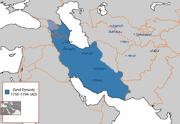
Map_of_the_Zand_dynasty.png (620 × 428 بكسل حجم الملف: 14 كيلوبايت، نوع MIME: image/png)
قالب:Uploaded with en.wp UW marker
| ⧼wm-license-information-description⧽ |
English: The Zand dynasty at its zenith under Karim Khan. Light-blue shows the Kingdom of Kartli-Kakheti, which was de jure under Zand rule, but de facto autonomous.
|
| ⧼wm-license-information-date⧽ | 2013 |
| ⧼wm-license-information-source⧽ | Based on the sources;
|
| ⧼wm-license-information-author⧽ | [1] Arab League/Arab Hafez and edited by HistoryofIran |
![[1]](http://en.wikipedia.org/wiki/File:Safavid_Empire_1501_1722_AD.png)
This file is in the public domain, because http://en.wikipedia.org/wiki/File:Safavid_Empire_1501_1722_AD.png
Please verify that the reason given above is valid!
Note: if there is a specific licence tag for the reason supplied here, please use it.
Note: if there is a specific licence tag for the reason supplied here, please use it.
تاريخ الملف
اضغط على زمن/تاريخ لرؤية الملف كما بدا في هذا الزمن.
| زمن/تاريخ | صورة مصغرة | الأبعاد | مستخدم | تعليق | |
|---|---|---|---|---|---|
| حالي | ★ مراجعة معتمدة 05:32، 16 أكتوبر 2023 | | 620 × 428 (14 كيلوبايت) | Pastakhov (نقاش | مساهمات) | Upload https://upload.wikimedia.org/wikipedia/commons/d/dd/Map_of_the_Zand_dynasty.png |
لا يمكنك استبدال هذا الملف.
وصلات
الصفحات التالية تحتوي على وصلة لهذه الصورة:
- إيران الكبرى
- ملف:ZanddynastyTrial.png (تحويلة ملف)