ملف:Map of ancient Dardania and environs (English).svg

حجم معاينة PNG لذلك الملف ذي الامتداد SVG: 800 × 445 بكسل. البعد الآخر: 2٬560 × 1٬423 بكسل.
الملف الأصلي (ملف SVG، أبعاده 1٬214 × 675 بكسل، حجم الملف: 378 كيلوبايت)
وصف قصير
| ⧼wm-license-information-description⧽ |
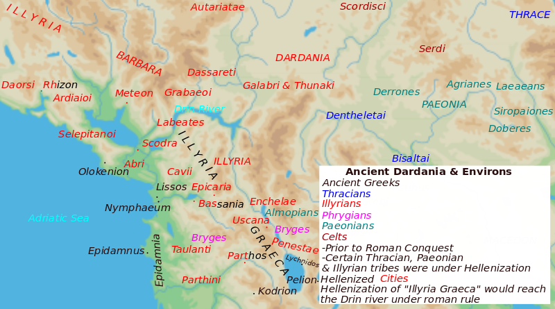
English: Map of Dardania & Environs prior to Roman conquest
|
| ⧼wm-license-information-date⧽ | 2016 |
| ⧼wm-license-information-source⧽ | ⧼Wm-license-own-work⧽ |
| ⧼wm-license-information-author⧽ | MaryroseB54 |
- The classical age of Greece (1999),
- ed. Atlas of the Greek and Roman world in antiquity (1981).
- Hammond, N. G. L. A History of Greece to 322 B.C., 1986, ISBN-10: 0198730950
- Wilkes, J. J. The Illyrians, 1992,ISBN 0631198075,
- In the Shadow of Olympus: The Emergence of Macedon,ISBN 0691008809,1992
- Thracian Tribal areas (from Fol, Thrace and the Thracians, p 133),The Thracians 700 BC–AD 46 (Men-at-Arms 360) by Christopher Webber After Hoddinot, Col & Cah
- Herman, Mogens. An Inventory of Archaic and Classical Poleis, 2004, p. 348, ISBN 0198140991
- Blank map from Image:Map greek sanctuaries-fr.svg.
ترخيص
|
تاريخ الملف
اضغط على زمن/تاريخ لرؤية الملف كما بدا في هذا الزمن.
| زمن/تاريخ | صورة مصغرة | الأبعاد | مستخدم | تعليق | |
|---|---|---|---|---|---|
| حالي | ★ مراجعة معتمدة 16:45، 20 أكتوبر 2023 | | 1٬214 × 675 (378 كيلوبايت) | Pastakhov (نقاش | مساهمات) | Upload https://upload.wikimedia.org/wikipedia/commons/b/b7/Map_of_ancient_Dardania_and_environs_%28English%29.svg |
لا يمكنك استبدال هذا الملف.
وصلات
لا يوجد صفحات تصل لهذه الصورة.
.svg&oldid=3192310)