ملف:Map of USA Deep South.svg

حجم معاينة PNG لذلك الملف ذي الامتداد SVG: 286 × 186 بكسل. البعد الآخر: 2٬560 × 1٬665 بكسل.
الملف الأصلي (ملف SVG، أبعاده 286 × 186 بكسل، حجم الملف: 97 كيلوبايت)
وصف قصير
| ⧼wm-license-information-description⧽ |
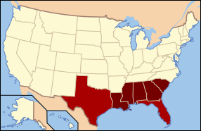
English: The states in dark red compose the Deep South today. Adjoining areas of Texas and North Florida are also considered part of this subregion.
|
| ⧼wm-license-information-date⧽ | |
| ⧼wm-license-information-source⧽ | Based off File:US map-Deep South States.png |
| ⧼wm-license-information-author⧽ | Connormah |
ترخيص
|

تاريخ الملف
اضغط على زمن/تاريخ لرؤية الملف كما بدا في هذا الزمن.
| زمن/تاريخ | صورة مصغرة | الأبعاد | مستخدم | تعليق | |
|---|---|---|---|---|---|
| حالي | ★ مراجعة معتمدة 03:19، 2 نوفمبر 2023 | | 286 × 186 (97 كيلوبايت) | Pastakhov (نقاش | مساهمات) | Upload https://upload.wikimedia.org/wikipedia/commons/3/35/Map_of_USA_Deep_South.svg |
لا يمكنك استبدال هذا الملف.
وصلات
لا يوجد صفحات تصل لهذه الصورة.