ملف:Map of Tennessee highlighting Metro Nashville.png
لا توجد دقة أعلى متوفرة.
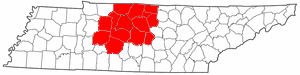
Map_of_Tennessee_highlighting_Metro_Nashville.png (300 × 75 بكسل حجم الملف: 11 كيلوبايت، نوع MIME: image/png)
وصف قصير
| ⧼wm-license-information-description⧽ |
English: Public domain map courtesy of The General Libraries, The University of Texas at Austin, modified to show counties. See Wikipedia:U.S. county maps.
|
| ⧼wm-license-information-date⧽ | قالب:Original upload date |
| ⧼wm-license-information-source⧽ | قالب:Transferred from |
| ⧼wm-license-information-author⧽ | قالب:User at project |
ترخيص
قالب:Original upload log
| زمن/تاريخ | الأبعاد | مستخدم | تعليق |
|---|---|---|---|
| 2013-04-23 03:20 | 300×75× (11556 bytes) | Aharmon1973 | Reverted to version as of 03:18, 23 April 2013 |
| 2013-04-23 03:19 | 300×75× (11556 bytes) | Aharmon1973 | Added Maury County per the February 2013 Office of Management and Budget announcement of metropolitan and micropolitan statistical areas |
| 2013-04-23 03:18 | 300×75× (11556 bytes) | Aharmon1973 | Added Maury County per the February 2013 Office of Management and Budget announcement of metropolitan and micropolitan statistical areas |
| 2005-06-08 03:05 | 300×75× (9656 bytes) | Dale Arnett | Public domain map courtesy of [http://www.lib.utexas.edu/ The General Libraries, The University of Texas at Austin], modified to show counties. {{GFDL}} See [[Wikipedia:U.S. county map]]s. |
تاريخ الملف
اضغط على زمن/تاريخ لرؤية الملف كما بدا في هذا الزمن.
| زمن/تاريخ | صورة مصغرة | الأبعاد | مستخدم | تعليق | |
|---|---|---|---|---|---|
| حالي | ★ مراجعة معتمدة 20:38، 11 نوفمبر 2023 | 300 × 75 (11 كيلوبايت) | Pastakhov (نقاش | مساهمات) | Upload https://upload.wikimedia.org/wikipedia/commons/3/33/Map_of_Tennessee_highlighting_Metro_Nashville.png |
لا يمكنك استبدال هذا الملف.
وصلات
لا يوجد صفحات تصل لهذه الصورة.