ملف:Map of Tarbat Parish 1878 County boundaries.jpg

حجم هذه المعاينة: 775 × 600 بكسل. البعد الآخر: 1٬000 × 774 بكسل.
الملف الأصلي (1٬000 × 774 بكسل حجم الملف: 292 كيلوبايت، نوع MIME: image/jpeg)
وصف قصير
| ⧼wm-license-information-description⧽ |
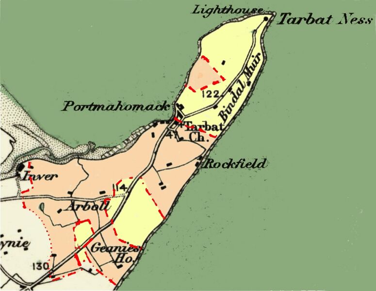
English: The map shows the borders of Tarbat parish (parish only: dotted, parish and county:dashed). Also shows the county boundaries within the parish. Ross is coloured pink. Cromarty is coloured yellow. Sources of information: (1)Ordnance Survey Quarter Inch to 1 Mile Sheet 8, publ. 1902; (2) Ordnance Survey 1 Inch to 1 Mile Sheet 94 - Cromarty, publ. 1878
|
| ⧼wm-license-information-date⧽ | 2021 |
| ⧼wm-license-information-source⧽ | ⧼Wm-license-own-work⧽ |
| ⧼wm-license-information-author⧽ | Tom1955 |
Relates to Tarbat parish (now also a community council area) in Ross and Cromarty, Scotland
ترخيص
|
تاريخ الملف
اضغط على زمن/تاريخ لرؤية الملف كما بدا في هذا الزمن.
| زمن/تاريخ | صورة مصغرة | الأبعاد | مستخدم | تعليق | |
|---|---|---|---|---|---|
| حالي | ★ مراجعة معتمدة 15:01، 23 أكتوبر 2023 | | 1٬000 × 774 (292 كيلوبايت) | Pastakhov (نقاش | مساهمات) | Upload https://upload.wikimedia.org/wikipedia/commons/0/00/Map_of_Tarbat_Parish_1878_County_boundaries.jpg |
لا يمكنك استبدال هذا الملف.
وصلات
لا يوجد صفحات تصل لهذه الصورة.