ملف:Map Parc Housen.png
لا توجد دقة أعلى متوفرة.
Map_Parc_Housen.png (203 × 270 بكسل حجم الملف: 7 كيلوبايت، نوع MIME: image/png)
وصف قصير
| ⧼wm-license-information-description⧽ |
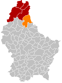
English: Parc Hosingen municipality location
Français : Situation de la commune luxembourgeoise du Parc Hosingen
|
| ⧼wm-license-information-date⧽ | قالب:Original upload date |
| ⧼wm-license-information-source⧽ | قالب:Transferred from |
| ⧼wm-license-information-author⧽ | قالب:User at project |
ترخيص
| [ This image has been (or is hereby) released into the public domain by its author, Les Meloures at the Wikipedia project. This applies worldwide. In case this is not legally possible: Deutsch · Ελληνικά · English · Plattdüütsch · 中文(简体) · 中文(繁體) · +/− |
قالب:Original upload log
قالب:Original description page
- 2011-10-27 19:01 Les Meloures 203×270× (3374 bytes) Verbessert Kaart
- 2011-10-26 23:32 Les Meloures 203×270× (3260 bytes) Localisatioun vun der Gemeng Parc Housen
تاريخ الملف
اضغط على زمن/تاريخ لرؤية الملف كما بدا في هذا الزمن.
| زمن/تاريخ | صورة مصغرة | الأبعاد | مستخدم | تعليق | |
|---|---|---|---|---|---|
| حالي | ★ مراجعة معتمدة 17:14، 22 يناير 2024 | | 203 × 270 (7 كيلوبايت) | Pastakhov (نقاش | مساهمات) | Upload https://upload.wikimedia.org/wikipedia/commons/b/b3/Map_Parc_Housen.png |
لا يمكنك استبدال هذا الملف.
وصلات
لا يوجد صفحات تصل لهذه الصورة.