ملف:MaineBoundaryDispute.jpg

الملف الأصلي (780 × 1٬102 بكسل حجم الملف: 306 كيلوبايت، نوع MIME: image/jpeg)

|
[All images in this gallery should be recreated using vector graphics as an SVG file. This has several advantages; see Commons:Media for cleanup for more information. If an SVG form of this image is already available, please upload it. After uploading an SVG, replace this template with {{vector version available|new image name.svg}}.] Error: {{Lang}}: text has italic markup (help) |
|
العربية | български | català | čeština | dansk | Deutsch | English | Esperanto | español | français | galego | 한국어 | italiano | magyar | lietuvių | 日本語 | Plattdüütsch | Nederlands | norsk | polski | português | română | русский | suomi | svenska | Türkçe | українська | 中文(繁體) | 中文(简体) | +/− | |
وصف قصير
| ⧼wm-license-information-description⧽ |
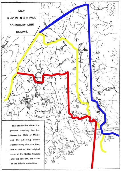
Map showing competing proposals for the boundary line between the US state of Maine and the British (now Canadian) province of New Brunswick. The red line marks the British proposal, the blue line marks the US proposal, and the yellow line marks the line agreed in the 1842 Webster-Ashburton Treaty, which resolved virtually all of the outstanding boundary issues in this area. |
| ⧼wm-license-information-date⧽ | Base map published 1888; annotations 2013 |
| ⧼wm-license-information-source⧽ | Base map: https://books.google.com/books?id=BEsyAQAAMAAJ&dq=%22fort%20sullivan%22%20eastport%20named&pg=PA134-IA1#v=onepage&q=sullivan&f=false Annotations: own work |
| ⧼wm-license-information-author⧽ | User:Magicpiano |
ترخيص
تاريخ الملف
اضغط على زمن/تاريخ لرؤية الملف كما بدا في هذا الزمن.
| زمن/تاريخ | صورة مصغرة | الأبعاد | مستخدم | تعليق | |
|---|---|---|---|---|---|
| حالي | ★ مراجعة معتمدة 09:01، 18 نوفمبر 2023 | | 780 × 1٬102 (306 كيلوبايت) | Pastakhov (نقاش | مساهمات) | Upload https://upload.wikimedia.org/wikipedia/commons/2/2c/MaineBoundaryDispute.jpg |
لا يمكنك استبدال هذا الملف.
وصلات
لا يوجد صفحات تصل لهذه الصورة.