ملف:MH370 Search Bathymetric Survey Data Zoom.jpg
حجم هذه المعاينة: 423 × 599 بكسل. البعدان الآخران: 1٬445 × 2٬048 بكسل | 3٬384 × 4٬794 بكسل.
الملف الأصلي (3٬384 × 4٬794 بكسل حجم الملف: 2٫93 ميجابايت، نوع MIME: image/jpeg)
وصف قصير
| ⧼wm-license-information-description⧽ |
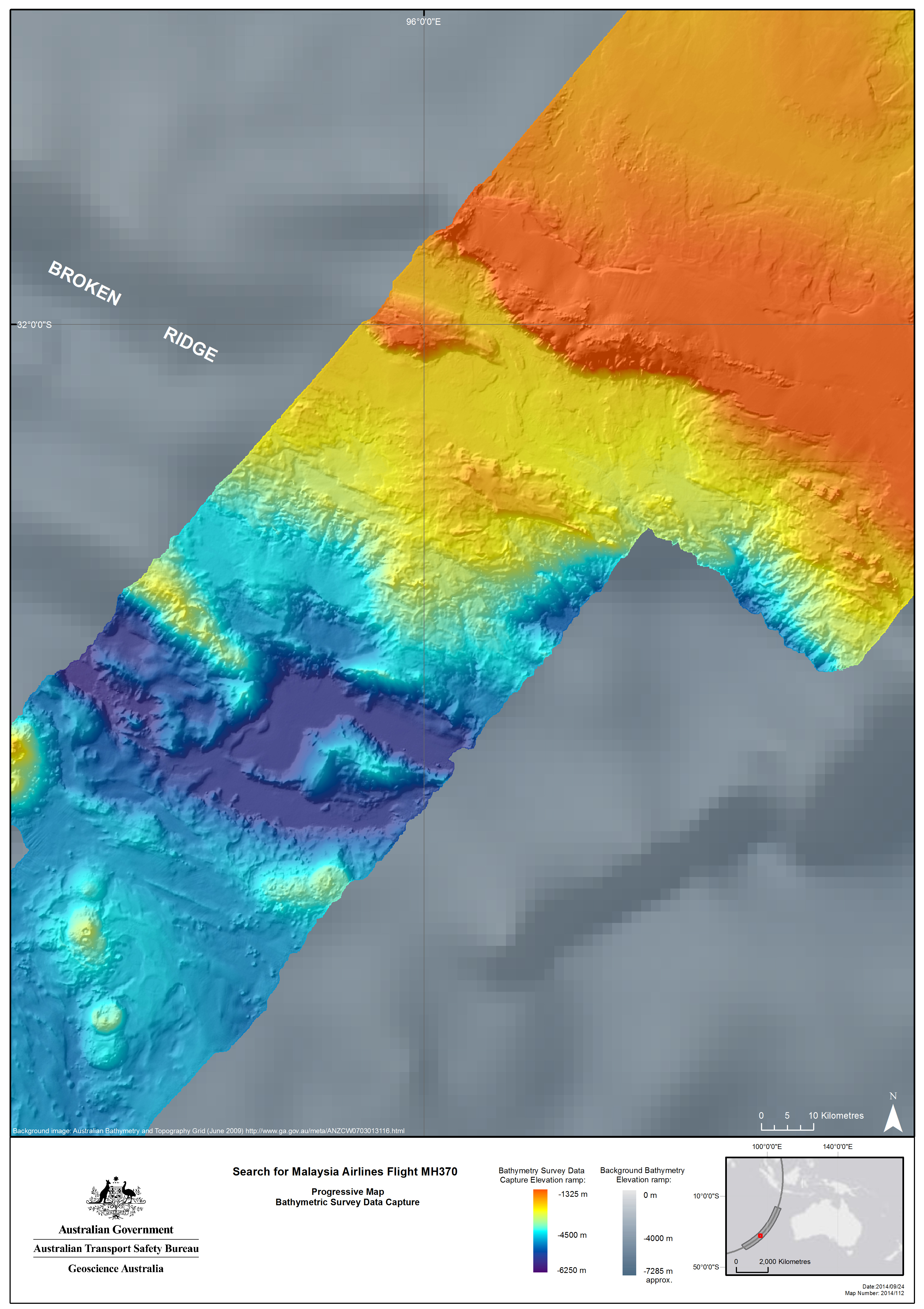
English: Image of bathymetric data obtained from a bathymetric survey conducted in the Southern Indian Ocean as part of the search for Malaysia Airlines Flight 370 (MH370) between March & September 2014. The grey area is bathymetric data that was acquired by satellite, which contrasts with the detailed data (colored) acquired by ships.
The bathymetric survey was conducted prior to an underwater search to be conducted by towed imaging devices, which will be maneuvered 100 m above the sea floor. The contrast in resolution between the satellite and the ship-conducted survey highlights the reason that the ship-conducted bathymetric survey was necessary before begining the underwater search.
|
| ⧼wm-license-information-date⧽ | 2014 |
| ⧼wm-license-information-source⧽ | http://www.atsb.gov.au/mh370/bathy-survey-data.aspx |
| ⧼wm-license-information-author⧽ | Australian Transport Safety Bureau |
| ⧼wm-license-information-permission⧽ (⧼wm-license-information-permission-reusing-text⧽) |
Obtained from the ATSB website, which states (link to "Copyright" at bottom): "© Copyright 2014, Commonwealth of Australia...Apart from the Coat of Arms, the ATSB logo, photos and graphics in which a third party has copyright, our investigation reports are licensed under the Creative Commons Attribution 3.0 Australia Licence." |
| ⧼wm-license-information-other-versions⧽ |
ملف:MH370 Search Bathymetric Survey Data.jpg View of full area of bathymetric survey. |
ترخيص
تاريخ الملف
اضغط على زمن/تاريخ لرؤية الملف كما بدا في هذا الزمن.
| زمن/تاريخ | صورة مصغرة | الأبعاد | مستخدم | تعليق | |
|---|---|---|---|---|---|
| حالي | ★ مراجعة معتمدة 16:33، 22 نوفمبر 2023 | | 3٬384 × 4٬794 (2٫93 ميجابايت) | Pastakhov (نقاش | مساهمات) | Upload https://upload.wikimedia.org/wikipedia/commons/2/28/MH370_Search_Bathymetric_Survey_Data_Zoom.jpg |
لا يمكنك استبدال هذا الملف.
وصلات
لا يوجد صفحات تصل لهذه الصورة.