ملف:London Underground full map.svg

حجم معاينة PNG لذلك الملف ذي الامتداد SVG: 800 × 467 بكسل. البعد الآخر: 2٬560 × 1٬493 بكسل.
الملف الأصلي (ملف SVG، أبعاده 6٬000 × 3٬500 بكسل، حجم الملف: 239 كيلوبايت)
| ⧼wm-license-information-description⧽ |
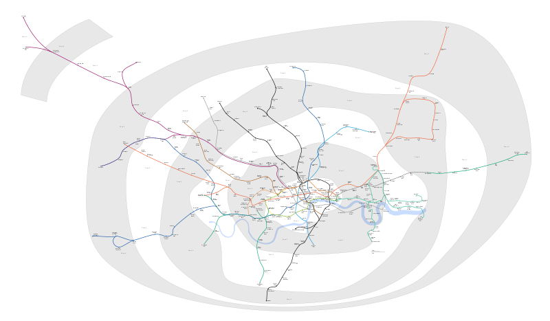
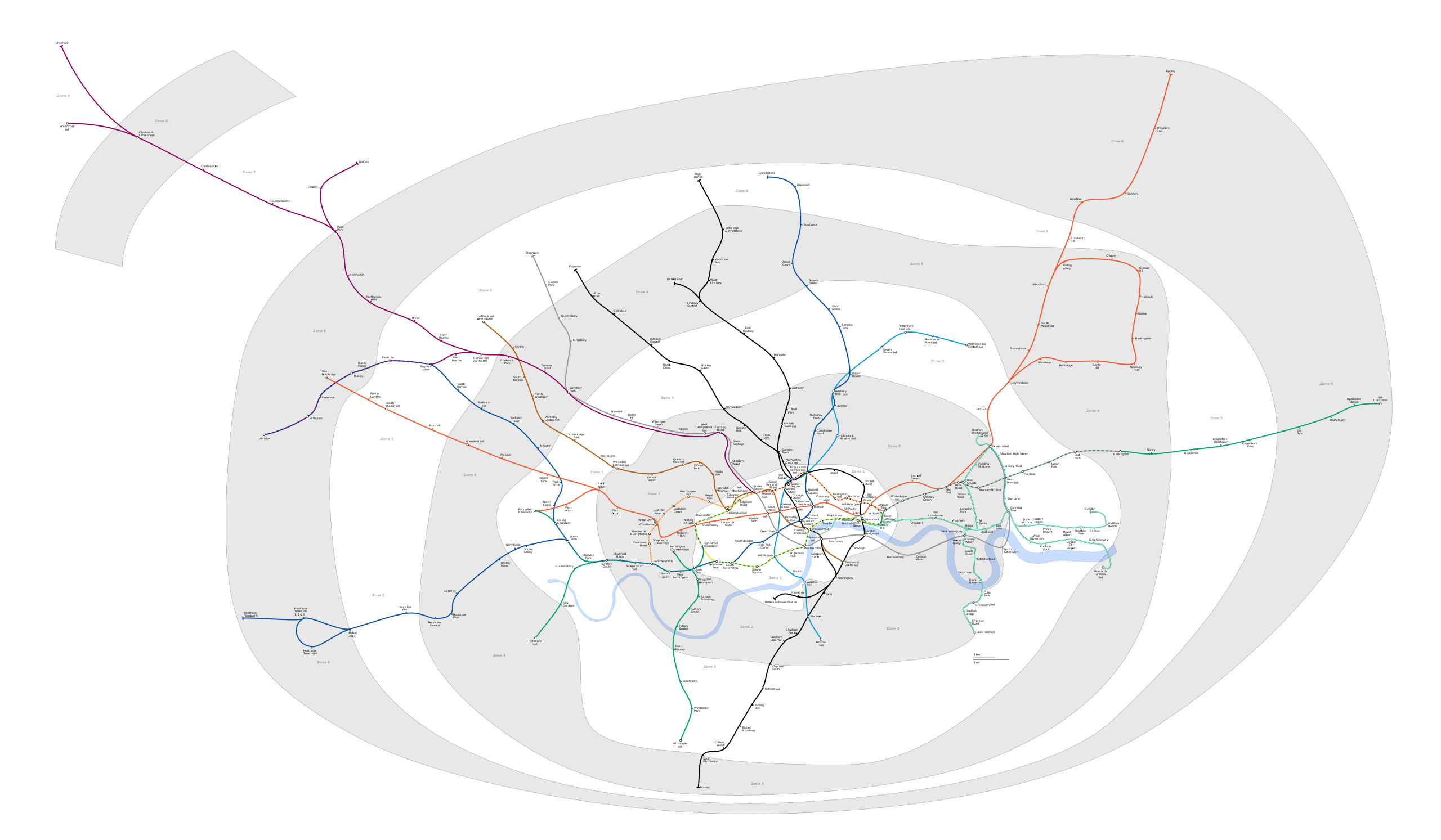
Geographic Map of the London Underground showing all stations with travelcard zones indicated |
|||
| ⧼wm-license-information-date⧽ | 2009-05-31 01:10 (UTC) | |||
| ⧼wm-license-information-source⧽ | ||||
| ⧼wm-license-information-author⧽ |
|
|||
| ⧼wm-license-information-permission⧽ (⧼wm-license-information-permission-reusing-text⧽) |
|
|||
| ⧼wm-license-information-other-versions⧽ |
PNG version: File:London Underground full map.png File:SW Chinese Map of the London Underground.svg |

قالب:Original upload log
This image is a derivative work of the following images:
- File:London_Underground_full_map.svg licensed with Cc-by-sa-2.5,2.0,1.0, GFDL
- 2009-05-31T00:05:06Z DavidCane 1000x570 (292205 Bytes) Stations added (in non visible section of map): Wood Lane, Woolwich Arsenal, Langdon Park. Station renamed: Shepherd' Bush to Shepherd's Bush Market
- 2009-04-07T12:50:10Z Ed g2s 1000x570 (287789 Bytes) remove external file references
- 2009-04-07T12:47:04Z Ed g2s 1000x570 (289202 Bytes) {{Information |Description={{en|1=London Underground map}} |Source=Own work by uploader |Author=[[User:Ed g2s|Ed g2s]] |Date= |Permission= |other_versions= }}
تاريخ الملف
اضغط على زمن/تاريخ لرؤية الملف كما بدا في هذا الزمن.
| زمن/تاريخ | صورة مصغرة | الأبعاد | مستخدم | تعليق | |
|---|---|---|---|---|---|
| حالي | ★ مراجعة معتمدة 11:45، 25 يناير 2024 | | 6٬000 × 3٬500 (239 كيلوبايت) | Pastakhov (نقاش | مساهمات) | Upload https://upload.wikimedia.org/wikipedia/commons/3/35/London_Underground_full_map.svg |
لا يمكنك استبدال هذا الملف.
وصلات
لا يوجد صفحات تصل لهذه الصورة.