ملف:Londinium Archäologische Karte.png

حجم هذه المعاينة: 598 × 600 بكسل. البعد الآخر: 1٬008 × 1٬011 بكسل.
الملف الأصلي (1٬008 × 1٬011 بكسل حجم الملف: 108 كيلوبايت، نوع MIME: image/png)
وصف قصير
| ⧼wm-license-information-description⧽ |
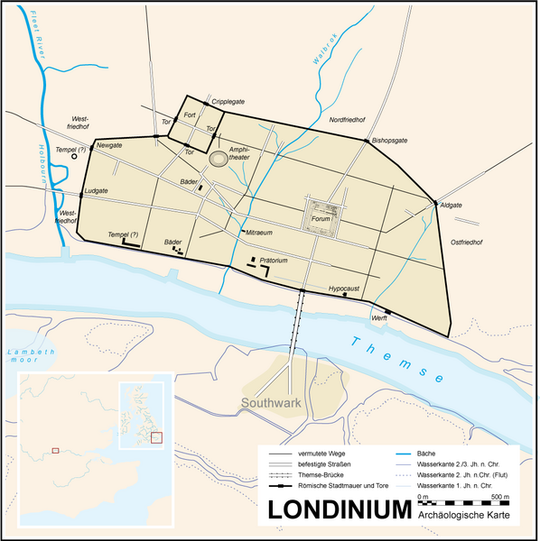
Deutsch: Karte des spätantiken Londons um 400 n. Chr.
|
| ⧼wm-license-information-date⧽ | 06.07.2007 |
| ⧼wm-license-information-source⧽ | own work / selbst hergestellt, base: image:Londinium3.jpg, image:London 1300 Historical Atlas William R Shepherd (died 1934).PNG |
| ⧼wm-license-information-author⧽ | Fremantleboy 06 July 2007 |
| ⧼wm-license-information-other-versions⧽ |
SVG-Version:
|

.PNG)
ترخيص
تاريخ الملف
اضغط على زمن/تاريخ لرؤية الملف كما بدا في هذا الزمن.
| زمن/تاريخ | صورة مصغرة | الأبعاد | مستخدم | تعليق | |
|---|---|---|---|---|---|
| حالي | ★ مراجعة معتمدة 13:14، 4 ديسمبر 2023 | | 1٬008 × 1٬011 (108 كيلوبايت) | Pastakhov (نقاش | مساهمات) | Upload https://upload.wikimedia.org/wikipedia/commons/2/24/Londinium_Arch%C3%A4ologische_Karte.png |
لا يمكنك استبدال هذا الملف.
وصلات
الصفحات التالية تحتوي على وصلة لهذه الصورة: