ملف:Limehouse Town Hall - geograph.org.uk - 788445.jpg
لا توجد دقة أعلى متوفرة.
Limehouse_Town_Hall_-_geograph.org.uk_-_788445.jpg (640 × 480 بكسل حجم الملف: 82 كيلوبايت، نوع MIME: image/jpeg)
وصف قصير
| ⧼wm-license-information-description⧽ |
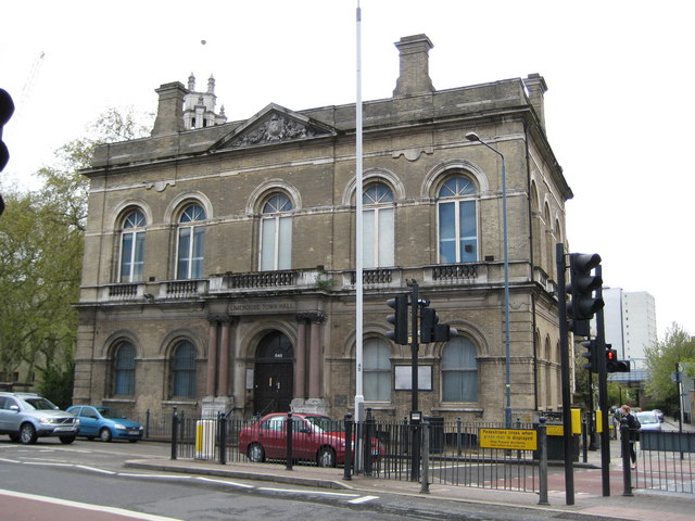
English: Limehouse Town Hall Limehouse probably got its name from the lime kilns established in the area around the fourteenth century. Chalk from Kent was brought up the River Thames and burnt in the kilns to make lime mortar and render used in the construction of buildings in London.
The Town Hall seen here was designed by the Harston architectural practice in an Italianate style and the foundation stone was laid in 1879. The building was completed in 1881 and it served as the Town Hall until the major local government reforms and the creation of Tower Hamlets Council in 1965. Since 1965 the building has had several functions including a period as the National Museum of Labour History. However it is currently in a bad state of disrepair and has been on English Heritage's Buildings at Risk Register since 2003. Funds from English Heritage have however been allocated for repair work to the Grade II listed structure.
|
| ⧼wm-license-information-date⧽ | 2008 |
| ⧼wm-license-information-source⧽ | From geograph.org.uk |
| ⧼wm-license-information-author⧽ | Nigel Cox |
| ⧼wm-license-cc-attribution⧽ (قالب:I18n/Credit line) |
Nigel Cox / Limehouse Town Hall / |
51°30′46″N 0°01′52″W / 51.5127°N 0.031°W قالب:Object location
_heading:157)
ترخيص
تاريخ الملف
اضغط على زمن/تاريخ لرؤية الملف كما بدا في هذا الزمن.
| زمن/تاريخ | صورة مصغرة | الأبعاد | مستخدم | تعليق | |
|---|---|---|---|---|---|
| حالي | ★ مراجعة معتمدة 22:59، 24 ديسمبر 2023 | | 640 × 480 (82 كيلوبايت) | Pastakhov (نقاش | مساهمات) | Upload https://upload.wikimedia.org/wikipedia/commons/b/b1/Limehouse_Town_Hall_-_geograph.org.uk_-_788445.jpg |
لا يمكنك استبدال هذا الملف.
وصلات
لا يوجد صفحات تصل لهذه الصورة.