ملف:Lake Huron bathymetry map.png
الملف الأصلي (936 × 1٬024 بكسل حجم الملف: 1٫35 ميجابايت، نوع MIME: image/png)
وصف قصير
| ⧼wm-license-information-description⧽ |
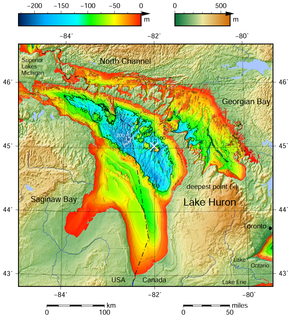
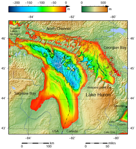
English: Lake Huron bathymetric shaded relief map contoured with interval 25 m (100 m with thicker lines). The deepest point is marked with "×". For land the vertical datum is sea level, for bathymetry low water datum of the lake.
The map was created using the Generic Mapping Tools, GMT, version 5.1.1. |
| ⧼wm-license-information-date⧽ | 2015 |
| ⧼wm-license-information-source⧽ | قالب:Own using the following Public Domain datasets (grids):
The coordinates of deepest point are taken from the NOAA Great LakesEnvironmental Research Laboratory webpage (www.glerl.noaa.gov/, kml file Google Earth Great Lakes Tour). |
| ⧼wm-license-information-author⧽ | Darekk2 using the Great Lakes Bathymetry and GLOBE tiles |
| ⧼wm-license-information-other-versions⧽ |
The same map but not shaded: Lake Huron bathymetry map 2.png |
ترخيص
Attribution (in addition to the author of this map):
The NGDC in it's copyright notice says:
As required by 17 U.S.C. 403, third parties producing copyrighted works consisting predominantly of the material produced by U.S. government agencies must provide notice with such work(s) identifying the U.S. Government material incorporated and stating that such material is not subject to copyright protection within the United States. (...)
(for credits see the Source section).
|
|
هذا العمل مرخّص تحت رخصة المشاع الإبداعي الملزمة بنسبة العمل لمؤلفه وبترخيص الأعمال المشتقة بالمثل 4.0. |
تاريخ الملف
اضغط على زمن/تاريخ لرؤية الملف كما بدا في هذا الزمن.
| زمن/تاريخ | صورة مصغرة | الأبعاد | مستخدم | تعليق | |
|---|---|---|---|---|---|
| حالي | ★ مراجعة معتمدة 12:33، 13 أكتوبر 2023 | | 936 × 1٬024 (1٫35 ميجابايت) | Pastakhov (نقاش | مساهمات) | Upload https://upload.wikimedia.org/wikipedia/commons/8/8c/Lake_Huron_bathymetry_map.png |
لا يمكنك استبدال هذا الملف.
وصلات
لا يوجد صفحات تصل لهذه الصورة.