ملف:Karte berlin stadtschloss.png

حجم هذه المعاينة: 595 × 599 بكسل. البعد الآخر: 1٬200 × 1٬209 بكسل.
الملف الأصلي (1٬200 × 1٬209 بكسل حجم الملف: 680 كيلوبايت، نوع MIME: image/png)
وصف قصير
| ⧼wm-license-information-description⧽ |
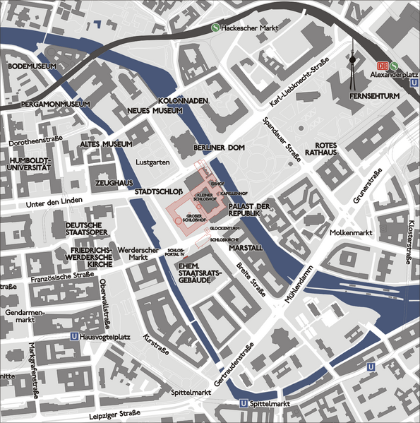
Lageplan des ehemaligen Berliner Stadtschlosses im heutigen Stadtgrundriss. In Rosa mit rotem Umriss Kubatur ca. 1930, südlich Schloßkirche und Glockenturm abgerissen 1750, nördlich der im Zuge des Straßenausbaus vor 1930 abgerissene Lustgartenflügel. |
| ⧼wm-license-information-date⧽ | قالب:Original upload date |
| ⧼wm-license-information-source⧽ | No machine-readable source provided. Own work assumed (based on copyright claims). |
| ⧼wm-license-information-author⧽ | No machine-readable author provided. Sansculotte assumed (based on copyright claims). |
ترخيص
تاريخ الملف
اضغط على زمن/تاريخ لرؤية الملف كما بدا في هذا الزمن.
| زمن/تاريخ | صورة مصغرة | الأبعاد | مستخدم | تعليق | |
|---|---|---|---|---|---|
| حالي | ★ مراجعة معتمدة 14:08، 1 ديسمبر 2023 | | 1٬200 × 1٬209 (680 كيلوبايت) | Pastakhov (نقاش | مساهمات) | Upload https://upload.wikimedia.org/wikipedia/commons/1/13/Karte_berlin_stadtschloss.png |
لا يمكنك استبدال هذا الملف.
وصلات
لا يوجد صفحات تصل لهذه الصورة.