ملف:Karte Hamburger Hafen 1910.jpg
حجم هذه المعاينة: 800 × 360 بكسل. البعد الآخر: 2٬512 × 1٬129 بكسل.
الملف الأصلي (2٬512 × 1٬129 بكسل حجم الملف: 3٫31 ميجابايت، نوع MIME: image/jpeg)
| ⧼wm-license-information-description⧽ |
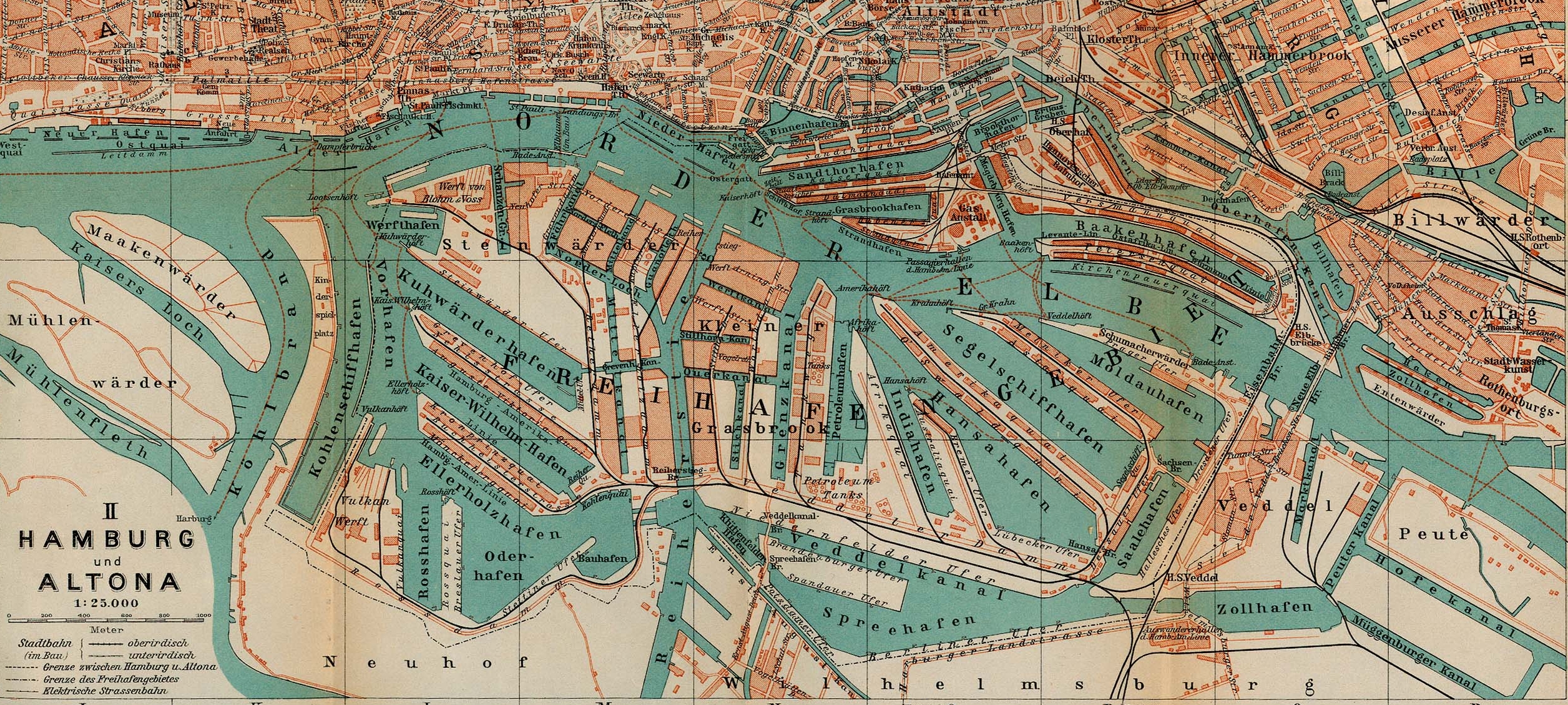
Map of Hamburg and Altona, Germany, 1910 |
| ⧼wm-license-information-date⧽ | 1910 |
| ⧼wm-license-information-source⧽ |
|
| ⧼wm-license-information-author⧽ |
|
| ⧼wm-license-information-other-versions⧽ |
| [This is a retouched picture, which means that it has been digitally altered from its original version. Modifications: ausschnitt. The original can be viewed here: Map_hamburg_altona_1910.jpg.] Error: {{Lang}}: text has italic markup (help)
|
قالب:Original upload log
This image is a derivative work of the following images:
- File:Map_hamburg_altona_1910.jpg licensed with PD-old
- 2009-05-16T08:24:40Z Emma7stern 2605x1980 (1696333 Bytes) Reverted to version as of 00:07, 23 April 2006
- 2009-05-16T08:21:47Z Emma7stern 911x1040 (1152518 Bytes) ausschnitt
- 2006-04-23T00:07:36Z 700 MB 2605x1980 (1696333 Bytes) {{Information| |Description=Map of Hamburg and Altona, Germany, 1910 |Source=http://www.lib.utexas.edu/maps/historical/baedeker_n_germany_1910/hamburg_altona_1910.jpg |Date=1910 |Author="Northern Germany as far as the Bavaria
تاريخ الملف
اضغط على زمن/تاريخ لرؤية الملف كما بدا في هذا الزمن.
| زمن/تاريخ | صورة مصغرة | الأبعاد | مستخدم | تعليق | |
|---|---|---|---|---|---|
| حالي | ★ مراجعة معتمدة 16:32، 14 أكتوبر 2023 | | 2٬512 × 1٬129 (3٫31 ميجابايت) | Pastakhov (نقاش | مساهمات) | Upload https://upload.wikimedia.org/wikipedia/commons/1/11/Karte_Hamburger_Hafen_1910.jpg |
لا يمكنك استبدال هذا الملف.
وصلات
لا يوجد صفحات تصل لهذه الصورة.
معلومات الصورة (ميتا)
تصنيفات:
- Maps of Hamburg-Altona-Altstadt
- Maps of Hamburg-Altstadt
- Maps of Hamburg-HafenCity
- Maps of Hamburg-Hammerbrook
- Maps of Hamburg-Kleiner Grasbrook
- Maps of Hamburg-Neustadt
- Maps of Hamburg-Rothenburgsort
- Maps of Hamburg-St. Pauli
- Maps of Hamburg-Steinwerder
- Maps of Hamburg-Veddel
- Maps of Hamburg-Wilhelmsburg
- Parts of old maps of Hamburg
- Port of Hamburg in the 1910s
- Northern Germany as far as the Bavarian and Austrian frontiers (1910) by BAEDEKER
- 1910 maps of Hamburg