ملف:Kangshung-06.PNG
حجم هذه المعاينة: 800 × 526 بكسل. البعد الآخر: 1٬157 × 761 بكسل.
الملف الأصلي (1٬157 × 761 بكسل حجم الملف: 1٫95 ميجابايت، نوع MIME: image/png)
وصف قصير
| ⧼wm-license-information-description⧽ |
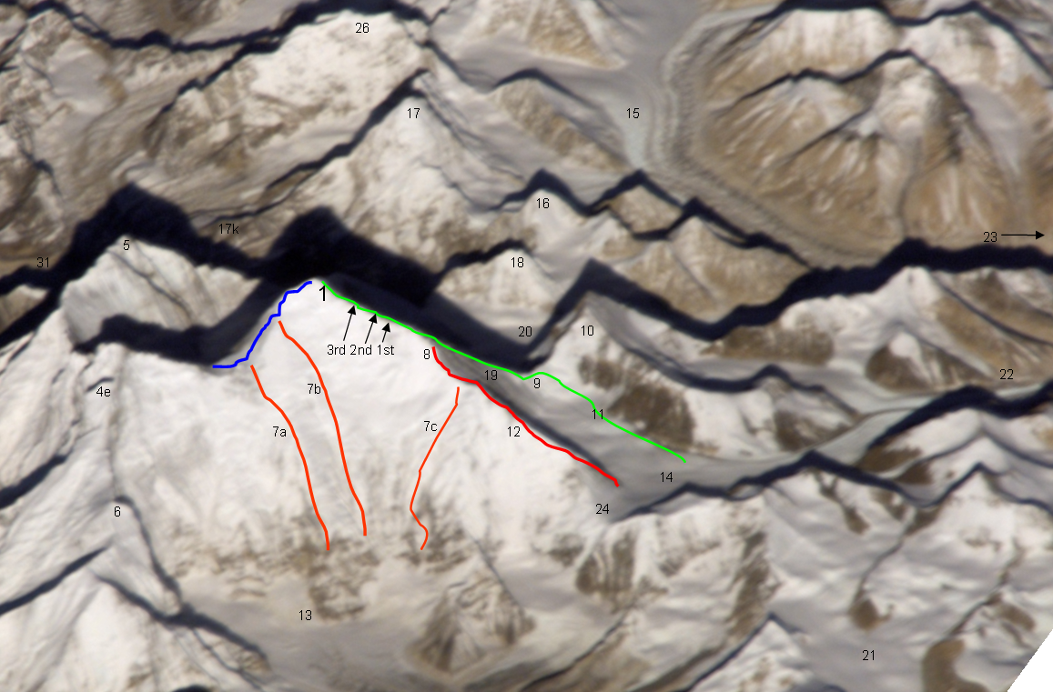
Deutsch: Ost- (Kangshung-) Wand des Mount Everest mit Umgebung
|
| ⧼wm-license-information-date⧽ | قالب:Original upload date |
| ⧼wm-license-information-source⧽ | قالب:Transferred from |
| ⧼wm-license-information-author⧽ | قالب:Author قالب:Author |
| ⧼wm-license-information-other-versions⧽ |
Notes
| green line | Normal route, mainly the Mallory route 1924, via high camps on 7700 and 8300 m, via "yellow band", exit cracks & upper NE ridge w. "Second Step") |
| red line / no.12 | lower and middle NE ridge |
| blue line | upper SE ridge (part of the «Hillary route» 1953 etc. coming from Western Qwm (in the shadow behind Mt. Everest) meeting point with the orange route 7a is the south col meeting point with the orange route 7b is the balcony |
| orange line 7a | 1988 US and GB ascent (Stephen Vernables et al.) |
| orange line 7b | 1982 US ascent (Carlos Buhler, Kim Momb et al.) |
| orange line 7c | “Phantasy Ridge” (acc. to a speech of George Mallory), no successful ascent until 2008, tried by Cathy O’Dowd and Ian Woodall; they came half way to NE ridge & Pinnacles |
| 1 | summit of Mount Everest 8848m |
| 3rd 2nd 1st | steps on the Upper NE ridge 8700m, 8605m and 8530m |
| 4e | Lhotse Shar |
| 5 | Nuptse |
| 6 | “Peak 38” |
| 13 | Kangshung Glacier |
| 8 | “Three Pinnacles” where Joe Tasker and Peter Boardman died 1982 (2nd pinnacle) |
| 9 | North Col on 7050m |
| 14 | East Rongbuk Glacier |
| 10 | Changtse (northern summit) |
| 11 | ABC Advanced Base Camp (North) on the upper East Rongbuk Glacier in front of the ice wall to north col |
| 15 | West Rongbuk Glacier (coming from the Cho Oyu and Gyachung Kang flanks) |
| 16 | Lingtren |
| 17 | Pumori |
| 17k | Kala Patthar, “Everest Trekking View Point” from the south side |
| 18 | Khumbutse (summit west of Lho La which is the connection on 6006m of the glacier systems of Rongbu and Khumbu and is also the tibetian-nepalian borderline / like SE ridge & W ridge. Lho La is "foot point" of the Everest W ridge.) |
| 19 | north ridge // below of fig. 19 the Zakharov Couloir offering a tough ascent to NE ridge without going via north col |
| 20 | Main Rongbuk Glacier |
| 21 | upper Kharta Glacier (Mallory 1921, where discovered the access to North Col) |
| 22 | Camp II of the early british expeditions 1922+1924 |
| 23 | to the Base camp on foot of the Main Rongbuk Glacier and to Rongbuk Gompa (Monastery) |
| 24 | Rapiu La (connection from Eastern Rongbuk Glacier System to Kangshung Glacier System) |
ترخيص
Original photograph:
|

قالب:Original upload log
قالب:Original description page
- 2008-11-12 20:39 Kassander der Minoer 1157×761× (2046200 bytes) {{Information |Beschreibung = Ost- (Kangshung-) Wand des Mount Everest mit Umgebung |Quelle = NASA & eigene Arbeit (Linien und Punkte markiert) |Urheber = NASA |Datum = 12.11.2008 |Genehmigung = US-Gov-GFDL |Andere Versionen = |Anmerkungen = }}
تاريخ الملف
اضغط على زمن/تاريخ لرؤية الملف كما بدا في هذا الزمن.
| زمن/تاريخ | صورة مصغرة | الأبعاد | مستخدم | تعليق | |
|---|---|---|---|---|---|
| حالي | ★ مراجعة معتمدة 10:46، 26 يناير 2024 | | 1٬157 × 761 (1٫95 ميجابايت) | Pastakhov (نقاش | مساهمات) | Upload https://upload.wikimedia.org/wikipedia/commons/9/93/Kangshung-06.PNG |
لا يمكنك استبدال هذا الملف.
وصلات
لا يوجد صفحات تصل لهذه الصورة.