ملف:KYTC district map.png
حجم هذه المعاينة: 800 × 345 بكسل. البعد الآخر: 1٬000 × 431 بكسل.
الملف الأصلي (1٬000 × 431 بكسل حجم الملف: 93 كيلوبايت، نوع MIME: image/png)
وصف قصير
| ⧼wm-license-information-description⧽ |
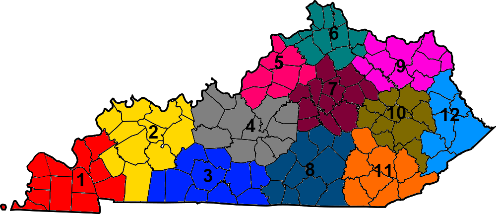
This is a locator map showing the Kentucky Transportation Cabinet districts. The numbers come from here. |
| ⧼wm-license-information-date⧽ | 2012-02-13 21:50 (UTC) |
| ⧼wm-license-information-source⧽ | قالب:Derived from |
| ⧼wm-license-information-author⧽ |
|
| [This is a retouched picture, which means that it has been digitally altered from its original version. Modifications: Added colors and numbers. The original can be viewed here: Map_of_Kentucky_highlighting_Ballard_County.svg. Modifications made by Presidentman.] Error: {{Lang}}: text has italic markup (help)
|
ترخيص
قالب:Original upload log
This image is a derivative work of the following images:
- File:Map_of_Kentucky_highlighting_Ballard_County.svg licensed with PD-self
- 2006-02-12T12:20:25Z David Benbennick 6770x2916 (129868 Bytes) {{subst:User:Dbenbenn/clm|county=Ballard County|state=Kentucky}}
تاريخ الملف
اضغط على زمن/تاريخ لرؤية الملف كما بدا في هذا الزمن.
| زمن/تاريخ | صورة مصغرة | الأبعاد | مستخدم | تعليق | |
|---|---|---|---|---|---|
| حالي | ★ مراجعة معتمدة 21:08، 20 أكتوبر 2023 | | 1٬000 × 431 (93 كيلوبايت) | Pastakhov (نقاش | مساهمات) | Upload https://upload.wikimedia.org/wikipedia/commons/5/50/KYTC_district_map.png |
لا يمكنك استبدال هذا الملف.
وصلات
لا يوجد صفحات تصل لهذه الصورة.