ملف:Innenstadtring (Berlin).png

حجم هذه المعاينة: 800 × 579 بكسل. البعد الآخر: 1٬680 × 1٬216 بكسل.
الملف الأصلي (1٬680 × 1٬216 بكسل حجم الملف: 2 ميجابايت، نوع MIME: image/png)
وصف قصير
| ⧼wm-license-information-description⧽ |
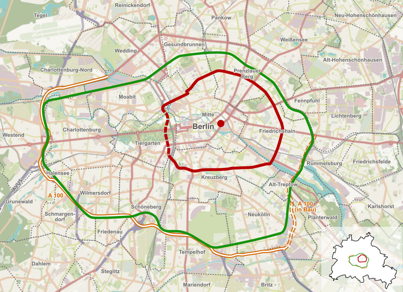
Deutsch: Der Innenstadtring (rot) innerhalb der Berliner Innenstadt, die ungefähr von der Ringbahn (grün) umschlossen wird. Das Rote Rathaus ist als roter Punkt markiert.
English: The Inner Ring Road (red) inside the inner city of Berlin that is bounded approximately by the circle line (green). The Red City Hall is marked with a red dot.
|
| ⧼wm-license-information-date⧽ | 2021 |
| ⧼wm-license-information-source⧽ | Own work, based on OpenStreetMap. https://www.openstreetmap.org/#map=12/52.5124/13.3412&layers=H |
| ⧼wm-license-information-author⧽ | TomTen, Contributers of OpenStreetMap |
ترخيص
تاريخ الملف
اضغط على زمن/تاريخ لرؤية الملف كما بدا في هذا الزمن.
| زمن/تاريخ | صورة مصغرة | الأبعاد | مستخدم | تعليق | |
|---|---|---|---|---|---|
| حالي | ★ مراجعة معتمدة 01:57، 12 نوفمبر 2023 | | 1٬680 × 1٬216 (2 ميجابايت) | Pastakhov (نقاش | مساهمات) | Upload https://upload.wikimedia.org/wikipedia/commons/e/e5/Innenstadtring_%28Berlin%29.png |
لا يمكنك استبدال هذا الملف.
وصلات
لا يوجد صفحات تصل لهذه الصورة.
.png&oldid=3478955)