ملف:Inini.png

حجم هذه المعاينة: 523 × 600 بكسل. البعد الآخر: 1٬884 × 2٬160 بكسل.
الملف الأصلي (1٬884 × 2٬160 بكسل حجم الملف: 71 كيلوبايت، نوع MIME: image/png)
وصف قصير
| ⧼wm-license-information-description⧽ |
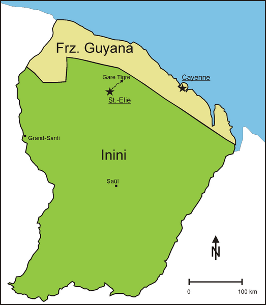
English: Division of French Guiana from 1930 to 1946 into a coastal strip, further called French Guiana, and the interior, administered as Territoire de l' Inini (Inini Territory)
Deutsch: Teilung Franz. Guyanas von 1930 bis 1946 in einen Küstenstreifen, der weiterhin Franz. Guyana genannt wurde und das Landesinnere, das unter dem Namen Inini verwaltet wurde.
|
| ⧼wm-license-information-date⧽ | 2011 |
| ⧼wm-license-information-source⧽ | ⧼Wm-license-own-work⧽, source for the northern boundary of Inini: http://www.waiapi-wayapi-teko.org/carte.htm |
| ⧼wm-license-information-author⧽ | Diorit |
ترخيص
تاريخ الملف
اضغط على زمن/تاريخ لرؤية الملف كما بدا في هذا الزمن.
| زمن/تاريخ | صورة مصغرة | الأبعاد | مستخدم | تعليق | |
|---|---|---|---|---|---|
| حالي | ★ مراجعة معتمدة 04:02، 22 أكتوبر 2023 | | 1٬884 × 2٬160 (71 كيلوبايت) | Pastakhov (نقاش | مساهمات) | Upload https://upload.wikimedia.org/wikipedia/commons/1/11/Inini.png |
لا يمكنك استبدال هذا الملف.
وصلات
لا يوجد صفحات تصل لهذه الصورة.