ملف:India Assam COVID-19 map.svg

حجم معاينة PNG لذلك الملف ذي الامتداد SVG: 725 × 600 بكسل. البعد الآخر: 2٬475 × 2٬048 بكسل.
الملف الأصلي (ملف SVG، أبعاده 765 × 633 بكسل، حجم الملف: 771 كيلوبايت)
وصف قصير
| ⧼wm-license-information-description⧽ |
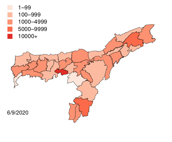
English: Districts with confirmed cases in the state of Assam.
|
| ⧼wm-license-information-date⧽ | 2020-04-07 18:34 (UTC) |
| ⧼wm-license-information-source⧽ | قالب:Derived from |
| ⧼wm-license-information-author⧽ | Firos AK |
| [This is a retouched picture, which means that it has been digitally altered from its original version. Modifications: coloured map for COVID 19. The original can be viewed here: Districts of Assam (2014).svg. Modifications made by Firos ak.] Error: {{Lang}}: text has italic markup (help)
|
ترخيص
|

.svg&action=edit&redlink=1)
قالب:Original upload log
This image is a derivative work of the following images:
- File:Assam-districts-2001.svg licensed with Cc-by-sa-3.0, GFDL
- 2011-08-19T23:27:48Z Chaipau 631x530 (215961 Bytes) Corrected the following districts: Nalbari, Barpeta, Sivasagar, Tinsukia
- 2009-04-05T11:02:24Z Chaipau 631x530 (168954 Bytes) The image is cropped to exclude empty spaces.
- 2009-04-05T01:14:33Z Chaipau 744x1052 (168532 Bytes) {{Information |Description={{en|1=This file shows the districts of [[en:Assam]] as of 2001. The map is based on a free hand trace of [http://web.archive.org/web/20040606141014/www.censusindia.net/results/2001maps/assam01.htm
تاريخ الملف
اضغط على زمن/تاريخ لرؤية الملف كما بدا في هذا الزمن.
| زمن/تاريخ | صورة مصغرة | الأبعاد | مستخدم | تعليق | |
|---|---|---|---|---|---|
| حالي | ★ مراجعة معتمدة 05:05، 5 ديسمبر 2023 | | 765 × 633 (771 كيلوبايت) | Pastakhov (نقاش | مساهمات) | Upload https://upload.wikimedia.org/wikipedia/commons/e/e9/India_Assam_COVID-19_map.svg |
لا يمكنك استبدال هذا الملف.
وصلات
لا يوجد صفحات تصل لهذه الصورة.