ملف:High Street - geograph.org.uk - 438394.jpg
لا توجد دقة أعلى متوفرة.
High_Street_-_geograph.org.uk_-_438394.jpg (640 × 427 بكسل حجم الملف: 65 كيلوبايت، نوع MIME: image/jpeg)
وصف قصير
| ⧼wm-license-information-description⧽ |
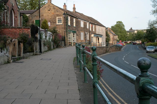
English: High Street Looking towards the High Green along the raised pavement past the Village Hall and Suggitts ice cream and tea shop. The pavement is raised here because the river used to overflow often. Below the car on the right is the culverted stream Skitterbeck which flows into the Leven just off picture. In March 1937 an eight year old boy, Bryce Petch, was swept away when the river overflowed. His father and the village postman both tried to save him. Both adults were drowned although the boy survived.
|
| ⧼wm-license-information-date⧽ | 2007 |
| ⧼wm-license-information-source⧽ | From geograph.org.uk |
| ⧼wm-license-information-author⧽ | Mick Garratt |
| ⧼wm-license-cc-attribution⧽ (قالب:I18n/Credit line) |
Mick Garratt / High Street / |
54°29′21″N 1°08′07″W / 54.48913°N 1.1354°W قالب:Object location
_heading:135)
ترخيص
تاريخ الملف
اضغط على زمن/تاريخ لرؤية الملف كما بدا في هذا الزمن.
| زمن/تاريخ | صورة مصغرة | الأبعاد | مستخدم | تعليق | |
|---|---|---|---|---|---|
| حالي | ★ مراجعة معتمدة 13:25، 9 نوفمبر 2023 | | 640 × 427 (65 كيلوبايت) | Pastakhov (نقاش | مساهمات) | Upload https://upload.wikimedia.org/wikipedia/commons/4/4f/High_Street_-_geograph.org.uk_-_438394.jpg |
لا يمكنك استبدال هذا الملف.
وصلات
لا يوجد صفحات تصل لهذه الصورة.