ملف:Herzogtum Westfalen und Umland etwa 1645.svg

حجم معاينة PNG لذلك الملف ذي الامتداد SVG: 704 × 459 بكسل. البعد الآخر: 2٬560 × 1٬669 بكسل.
الملف الأصلي (ملف SVG، أبعاده 704 × 459 بكسل، حجم الملف: 213 كيلوبايت)
| ⧼wm-license-information-description⧽ |
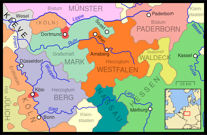
Deutsch: Karte des Herzogtum Westfalen und angrenzender Staaten etwa um 1645. Köln und Dortmund waren Freie Reichsstädte. Die vielen kleinen Staaten im Hessischen und Nassauischen sowie andere Kleinstaaten sind nicht alle einzeln dargestellt, ein heller Gelbton stellt ihre Flächen dar.
English: A map showing the Duchy of Westphalia and other western German states in the year 1645. Cologne and Dortmund were w:en:Free Imperial Cities. The various small Nassau and Hessian states are not shown separately. The smaller states are also not differentiated, but rather are shown in a light cream color.
|
| ⧼wm-license-information-date⧽ | 2009-12-20 15:06 (UTC) |
| ⧼wm-license-information-source⧽ | |
| ⧼wm-license-information-author⧽ |
|
| [This is a retouched picture, which means that it has been digitally altered from its original version. Modifications: translation. The original can be viewed here: Duchy_of_Wesphalia_and_other_states,_circa_1645.svg. Modifications made by NordNordWest.] Error: {{Lang}}: text has italic markup (help)
|
قالب:Original upload log
This image is a derivative work of the following images:
- File:Duchy_of_Wesphalia_and_other_states,_circa_1645.svg licensed with Cc-by-3.0
- 2009-10-16T04:03:50Z MapMaster 704x459 (221566 Bytes) Needed to change page size to properly reflect enlarged drawing
- 2009-10-15T21:48:45Z MapMaster 352x229 (221566 Bytes) More river names, strict font usage, twice as large.
- 2009-10-15T17:42:17Z MapMaster 352x229 (212588 Bytes) {{Information |Description={{en|1=A map showing the Duchy of Westphalia and other eastern German states in the year 1645.}} |Source=Own work |Author=[[User:MapMaster|MapMaster]] |Date=15 October 2009 |Permission= |other_versi
تاريخ الملف
اضغط على زمن/تاريخ لرؤية الملف كما بدا في هذا الزمن.
| زمن/تاريخ | صورة مصغرة | الأبعاد | مستخدم | تعليق | |
|---|---|---|---|---|---|
| حالي | ★ مراجعة معتمدة 14:06، 9 نوفمبر 2023 | | 704 × 459 (213 كيلوبايت) | Pastakhov (نقاش | مساهمات) | Upload https://upload.wikimedia.org/wikipedia/commons/f/fa/Herzogtum_Westfalen_und_Umland_etwa_1645.svg |
لا يمكنك استبدال هذا الملف.
وصلات
لا يوجد صفحات تصل لهذه الصورة.