ملف:Ground Deformation from Chilean Volcanic Eruption Shown by Satellite Radar Image.png

حجم هذه المعاينة: 800 × 480 بكسل. البعد الآخر: 2٬881 × 1٬729 بكسل.
الملف الأصلي (2٬881 × 1٬729 بكسل حجم الملف: 13٫81 ميجابايت، نوع MIME: image/png)
وصف قصير
| ⧼wm-license-information-description⧽ |
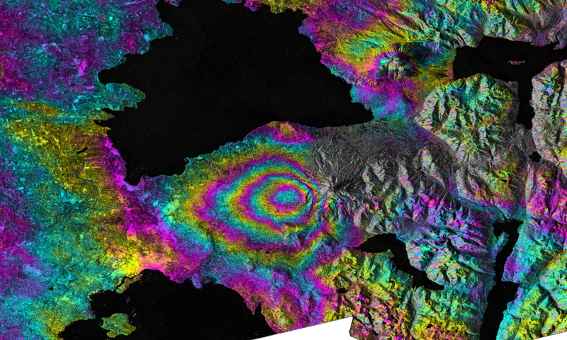
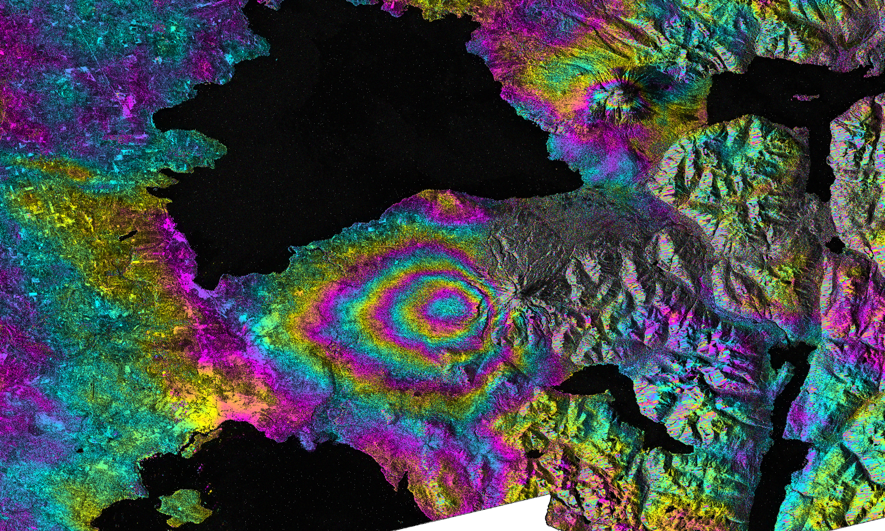
English: On April 22-23, 2015, significant explosive eruptions occurred at Calbuco volcano, Chile. This was the first eruptive activity at Calbuco since 1972. A satellite interferometric synthetic aperture radar image was created by Paul Lundgren of NASA's Jet Propulsion Laboratory in Pasadena, Calif., using data acquired from the European Space Agency's (ESA) Sentinel-1 radar satellite's C-SAR sensor. This image depicts the relative deformation of Earth's surface using radar data acquired on April 14 and 26, 2015, that span the eruption. The concentric, "leaf-shaped" pattern of fringes (color cycles) lies to the west of Calbuco volcano and represents subsidence of the ground surface due to deflation of a buried magma reservoir. The black areas in the image represent water, to the north lies Lago Llanquihue and to the south lies Puerto Montt Bay (Pacific Ocean).
Image Details Target: Earth Spacecraft: Sentinel-1A Instrument: C-SAR Sensor Views: 132 Full-Res TIFF: PIA11434.tif (11.55 MB) Full-Res JPG: PIA11434.jpg (1.66 MB) Image credit: ESA/NASA/JPL-Caltech |
| ⧼wm-license-information-date⧽ | 2015-04-22-23 |
| ⧼wm-license-information-source⧽ | http://photojournal.jpl.nasa.gov/archive/PIA11434_filt_fine.3alks_9rlks_S12.unw.geo.png |
| ⧼wm-license-information-author⧽ | Image credit: ESA/NASA/JPL-Caltech |
ترخيص
تاريخ الملف
اضغط على زمن/تاريخ لرؤية الملف كما بدا في هذا الزمن.
| زمن/تاريخ | صورة مصغرة | الأبعاد | مستخدم | تعليق | |
|---|---|---|---|---|---|
| حالي | ★ مراجعة معتمدة 16:30، 30 نوفمبر 2023 | | 2٬881 × 1٬729 (13٫81 ميجابايت) | Pastakhov (نقاش | مساهمات) | Upload https://upload.wikimedia.org/wikipedia/commons/d/d7/Ground_Deformation_from_Chilean_Volcanic_Eruption_Shown_by_Satellite_Radar_Image.png |
لا يمكنك استبدال هذا الملف.
وصلات
لا يوجد صفحات تصل لهذه الصورة.