ملف:GreaterGrandForksareamap.png
لا توجد دقة أعلى متوفرة.
GreaterGrandForksareamap.png (372 × 217 بكسل حجم الملف: 10 كيلوبايت، نوع MIME: image/png)
وصف قصير
| ⧼wm-license-information-description⧽ | |
| ⧼wm-license-information-date⧽ | قالب:Original upload date |
| ⧼wm-license-information-source⧽ | قالب:Transferred from |
| ⧼wm-license-information-author⧽ | قالب:User at project |
![[1]](http://upload.wikimedia.org/wikipedia/commons/f/f6/Map_of_USA_with_county_outlines.png)
ترخيص
قالب:Original upload log
قالب:Original description page
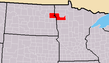
- 2009-03-02 07:12 Milk the cows 372×217× (10503 bytes) Taken from this Wikipedia map: [http://upload.wikimedia.org/wikipedia/commons/f/f6/Map_of_USA_with_county_outlines.png] and the information is from the US Census here: [http://www.census.gov/geo/www/maps/msa_maps2005/msa2005_previews_html/cbsa_csa_us_wall
- 2007-07-20 21:50 Milk the cows 375×200× (19562 bytes) == Summary == MSA of the [[Greater Grand Forks]] area and other associated with Grand Forks. Adapted from Wikipedia's ND and MN county maps by Seth Ilys. == Licensing == {{PD-self}}
تاريخ الملف
اضغط على زمن/تاريخ لرؤية الملف كما بدا في هذا الزمن.
| زمن/تاريخ | صورة مصغرة | الأبعاد | مستخدم | تعليق | |
|---|---|---|---|---|---|
| حالي | ★ مراجعة معتمدة 09:48، 10 أكتوبر 2023 | | 372 × 217 (10 كيلوبايت) | Pastakhov (نقاش | مساهمات) | Upload https://upload.wikimedia.org/wikipedia/commons/4/41/GreaterGrandForksareamap.png |
لا يمكنك استبدال هذا الملف.
وصلات
لا يوجد صفحات تصل لهذه الصورة.